
Carte topographique Lake Sammamish
Carte interactive
Cliquez sur la carte pour afficher l’altitude.
À propos de cette carte
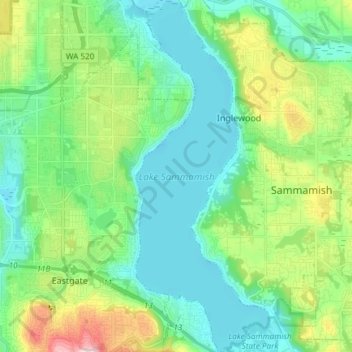
Nom : Carte topographique Lake Sammamish, altitude, relief.
Altitude moyenne : 88 m
Altitude minimum : 0 m
Altitude maximum : 344 m
Autres cartes topographiques
Cliquez sur une carte pour visualiser sa topographie, son altitude et son relief.
West Tiger Mountain Natural Resource Conservation Area
United States > Washington > King County > Issaquah
West Tiger Mountain Natural Resource Conservation Area, Issaquah, King County, Washington, United States
Altitude moyenne : 101 m
Grand View Park
United States > Washington > King County > Issaquah
Grand View Park, Kirk Park, Issaquah, King County, Washington, 98029, United States
Altitude moyenne : 202 m