
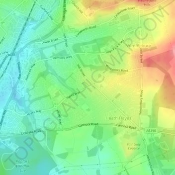
Carte topographique Heath Hayes and Wimblebury
Carte interactive
Cliquez sur la carte pour afficher l’altitude.
À propos de cette carte
Nom : Carte topographique Heath Hayes and Wimblebury, altitude, relief.
Altitude moyenne : 170 m
Altitude minimum : 136 m
Altitude maximum : 224 m
Autres cartes topographiques
Cliquez sur une carte pour visualiser sa topographie, son altitude et son relief.
Wimblebury
United Kingdom > England > Cannock Chase > Wimblebury
Wimblebury, Cannock Chase, Staffordshire, West Midlands, England, WS12 2AB, United Kingdom
Altitude moyenne : 184 m
Hednesford
United Kingdom > England > Cannock Chase > Hednesford
Hednesford, Staffordshire, West Midlands, England, WS12 4AH, United Kingdom
Altitude moyenne : 167 m
Heath Hayes
United Kingdom > England > Cannock Chase > Heath Hayes
Heath Hayes, Cannock Chase, Staffordshire, West Midlands, England, WS12 3HE, United Kingdom
Altitude moyenne : 170 m
Cannock Extension Canal
United Kingdom > England > Cannock Chase
Cannock Extension Canal, Cannock Chase, Staffordshire, West Midlands, England, WS3 5AW, United Kingdom
Altitude moyenne : 145 m