Géolocaliser

Carte topographique Reading

Cliquez sur la carte pour afficher l’altitude.

Reading

Jane Austen attended Reading Ladies Boarding School, based in the Abbey Gateway, in 1784–1786. Mary Russell Mitford lived in Reading for a number of years and then spent the rest of her life just outside the town at Three Mile Cross and Swallowfield. The fictional Belford Regis of her eponymous novel, first published in 1835, is largely based on Reading. Described with topographical accuracy, it is still possible to follow the steps of the novel's characters in present-day Reading. Reading also appears in the works of Thomas Hardy where it is called 'Aldbrickham'. It features most heavily in his final novel, Jude the Obscure, as the temporary home of Jude Fawley and Sue Bridehead.

Wikipedia (CC-BY-SA 3.0)

À propos de cette carte

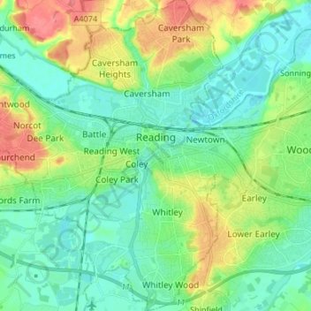
Nom : Carte topographique Reading, altitude, relief.

Lieu : Reading, England, United Kingdom (51.40975 -1.05299 51.49313 -0.92849)

Altitude moyenne : 54 m

Altitude minimum : 32 m

Altitude maximum : 104 m

Autres cartes topographiques

Cliquez sur une carte pour visualiser sa topographie, son altitude et son relief.

London

United Kingdom > England > London

Altitude moyenne : 42 m

Cambridge

United Kingdom > England > Cambridge

The city, like most of the UK, has a maritime climate highly influenced by the Gulf Stream. Located in the driest region of Britain, Cambridge's rainfall averages around 570 mm (22.44 in) per year, around half the national average, with some years occasionally falling into the semi-arid (under 500 mm (19.69…

Altitude moyenne : 18 m

Leeds

United Kingdom > England

Lying in the eastern foothills of the Pennines, there is a significant variation in elevation within the city's built-up area. The district ranges from 1,115 feet (340 m) in the far west on the slopes of Ilkley Moor to about 33 feet (10 m) where the rivers Aire and Wharfe cross the eastern boundary. Land rises…

Altitude moyenne : 94 m

Richmond Park

United Kingdom > England > Greater London

Altitude moyenne : 26 m

Brighton

United Kingdom > England > Brighton and Hove

Altitude moyenne : 64 m

York

United Kingdom > England > York

Altitude moyenne : 21 m

Leicester

United Kingdom > England > City of Leicester

Altitude moyenne : 109 m

City of London

United Kingdom > England > City of London > City of London

The elevation of the City ranges from sea level at the Thames to 21.6 metres (71 ft) at the junction of High Holborn and Chancery Lane. Two small but notable hills are within the historic core, Ludgate Hill to the west and Cornhill to the east. Between them ran the Walbrook, one of the many "lost" rivers or…

Altitude moyenne : 42 m

Skipton

United Kingdom > England > Skipton

Altitude moyenne : 201 m

Hull

United Kingdom > England > Kingston upon Hull

Kingston upon Hull is on the northern bank of the Humber Estuary. The city centre is west of the River Hull and close to the Humber. The city is built upon alluvial and glacial deposits which overlie chalk rocks but the underlying chalk has no influence on the topography. The land within the city is generally…

Altitude moyenne : 21 m

Hebden Bridge

United Kingdom > England > Calderdale

Altitude moyenne : 277 m

Malvern

United Kingdom > England > Worcestershire > Malvern Hills

Malvern lies in the Lower Severn/Avon plain affording it a degree of shelter caused by virtue of its nestling in between the Cotswold hills to the east, the Welsh Hills and Mountains to the west, and Birmingham plateau to the north. Although as with all the British Isles it has a maritime climate, the local…

Altitude moyenne : 95 m

Portsmouth

United Kingdom > England > Hampshire > Portsmouth

By road, Portsmouth lies 73.5 miles (118.3 km) from Central London, 49.5 miles (79.7 km) west of Brighton, and 22.3 miles (35.9 km) east of Southampton. Portsmouth is situated primarily on Portsea Island and is the United Kingdom's only island city, although parts of it have expanded onto the mainland. Gosport…

Altitude moyenne : 28 m

Salisbury

United Kingdom > England > Salisbury

Bishop of Salisbury Hubert Walter was instrumental in the negotiations with Saladin during the Third Crusade, but he spent little time in his diocese prior to his elevation to archbishop of Canterbury. The brothers Herbert and Richard Poore succeeded him and began planning the relocation of the cathedral into…

Altitude moyenne : 96 m

Derby

United Kingdom > England > Derbyshire

Altitude moyenne : 97 m

Crystal Palace Park

United Kingdom > England > London

Altitude moyenne : 73 m

Isles of Scilly

United Kingdom > England

Altitude moyenne : 2 m

Walthamstow

United Kingdom > England

Altitude moyenne : 21 m

Ely

United Kingdom > England > Ely

For over 800 years the cathedral and its associated buildings—built on an elevation 68 feet (21 m) above the nearby fens—have visually influenced the city and its surrounding area. Geographer John Jones, writing in 1924, reports that "from the roof of King's Chapel in Cambridge, on a clear day, Ely can be…

Altitude moyenne : 13 m

Carlisle

United Kingdom > England > Cumberland

Altitude moyenne : 31 m

Croydon

United Kingdom > England > Greater London

Several apartment developments, for instance Altitude 25 (completed 2010), have been built in recent years, and several more are being built or planned. The construction of Saffron Square, which includes a 43-storey tower, began on Wellesley Road in 2011 and was completed in 2016. Other developments with…

Altitude moyenne : 70 m

Torquay

United Kingdom > England > Torbay

Altitude moyenne : 31 m

Swindon

United Kingdom > England > Swindon

Swindon has an oceanic climate (Cfb in the Köppen climate classification), like the vast majority of the British Isles, with cool winters and warm summers. The nearest official weather station is RAF Lyneham, about 10 miles (16 km) west southwest of Swindon town centre. The weather station's elevation is 145…

Altitude moyenne : 108 m

Plymouth

United Kingdom > England > Devon > Plymouth

The River Plym, which flows off Dartmoor to the north-east, forms a smaller estuary to the east of the city called Cattewater. Plymouth Sound is protected from the sea by the Plymouth Breakwater, in use since 1814. In the Sound is Drake's Island which is seen from Plymouth Hoe, a flat public area on top of…

Altitude moyenne : 81 m

Poole Bay

United Kingdom > England

Altitude moyenne : 0 m

Bideford Bay

United Kingdom > England

Altitude moyenne : 0 m

Mount's Bay

United Kingdom > England

Altitude moyenne : 0 m

Falmouth Bay

United Kingdom > England

Altitude moyenne : 0 m

Lyme Bay

United Kingdom > England

Altitude moyenne : 0 m

Liverpool Bay

United Kingdom > England

Altitude moyenne : 0 m

Gayton

United Kingdom > England

Altitude moyenne : 41 m

Burtonwood

United Kingdom > England > Warrington

Altitude moyenne : 26 m

Harefield

United Kingdom > England

Altitude moyenne : 66 m

Whitefield

United Kingdom > England

Altitude moyenne : 91 m

Lewisham

United Kingdom > England

Altitude moyenne : 28 m

Scafell Pike

United Kingdom > England > Cumberland

Scafell Pike (/ˈskɔːfɛl paɪk/) is the highest and the most prominent mountain in England, at an elevation of 978 metres (3,209 ft) above sea level. It is located in the Lake District National Park, in Cumbria, and is part of the Southern Fells and the Scafell massif.

Altitude moyenne : 679 m

Falmouth

United Kingdom > England > Falmouth

Altitude moyenne : 33 m

Banbury

United Kingdom > England > Cherwell > Banbury

Altitude moyenne : 119 m

Enfield

United Kingdom > England

Altitude moyenne : 39 m

Burton upon Trent

United Kingdom > England > Staffordshire > East Staffordshire

Burton is about 109 miles (175 km) north west of London, about 30 miles north east of Birmingham, the UK's second largest city and about 23 miles east of the county town Stafford. It is at the easternmost border of the county of Staffordshire with Derbyshire, its suburbs and the course of the River Trent…

Altitude moyenne : 69 m

Reading

United Kingdom > England > Reading

Mary Russell Mitford lived in Reading for a number of years and then spent the rest of her life just outside the town at Three Mile Cross and Swallowfield. The fictional Belford Regis of her eponymous novel, first published in 1835, is largely based on Reading. Described with topographical accuracy, it is…

Altitude moyenne : 56 m

Peterborough

United Kingdom > England > Cambridgeshire

The local topography is flat, and in some places, the land lies below sea level, for example in parts of the Fens to the east and to the south of Peterborough. Human settlement in the area began before the Bronze Age, as can be seen at the Flag Fen archaeological site to the east of the current city centre,…

Altitude moyenne : 17 m

Croyde

United Kingdom > England > Devon > North Devon

Altitude moyenne : 51 m

Middleyard

United Kingdom > England > Gloucestershire

Altitude moyenne : 109 m

Farnworth

United Kingdom > England

Altitude moyenne : 94 m

Keston

United Kingdom > England

Altitude moyenne : 104 m

Eastham Village

United Kingdom > England

Altitude moyenne : 24 m

Greasby

United Kingdom > England

Altitude moyenne : 32 m

Tottenham

United Kingdom > England

Tottenham's elevation is approximately 33 ft (10 m) above sea level.

Altitude moyenne : 25 m

Dinnington

United Kingdom > England

Altitude moyenne : 91 m

Brownhills

United Kingdom > England

Altitude moyenne : 140 m

Chipping Barnet

United Kingdom > England > Greater London

Its name is very often abbreviated to just Barnet, which is also the name of the borough of which it forms a part; the town has been part of Greater London since 1965 after the abolition of Barnet Urban District then in Hertfordshire. Chipping Barnet is also the name of the Parliamentary constituency covering…

Altitude moyenne : 95 m

Ashton-in-Makerfield

United Kingdom > England

Altitude moyenne : 51 m

Wimbledon

United Kingdom > England > Greater London

Altitude moyenne : 26 m

Hampstead Heath

United Kingdom > England > London

Altitude moyenne : 94 m

Scunthorpe

United Kingdom > England > North Lincolnshire

Altitude moyenne : 28 m

Portishead

United Kingdom > England > Portishead

Altitude moyenne : 26 m

Stourbridge

United Kingdom > England

Altitude moyenne : 113 m

Chippenham

United Kingdom > England > Chippenham

Altitude moyenne : 76 m

Taunton

United Kingdom > England > Somerset

Altitude moyenne : 39 m

St Albans

United Kingdom > England > Hertfordshire > St Albans

St Albans was an ancient borough created following the dissolution of the monastery in 1539. It consisted of the ancient parish of St Albans (also known as the Abbey parish) and parts of St Michael and St Peter. The municipal corporation was reformed by the Municipal Corporations Act 1835 and the boundary was…

Altitude moyenne : 100 m

Bromley

United Kingdom > England > Greater London

Altitude moyenne : 62 m

Bedford

United Kingdom > England > Bedford

As with the rest of the United Kingdom, Bedford has a maritime climate, with a limited range of temperatures, and generally even rainfall throughout the year. The nearest Met Office weather station to Bedford is Bedford (Thurleigh) airport, about 6.5 miles (10.5 km) north of Bedford town centre at an elevation…

Altitude moyenne : 37 m

Shimpling Street

United Kingdom > England > Suffolk > Babergh > Shimpling

Altitude moyenne : 87 m

Cleehill

United Kingdom > England > Shropshire

Altitude moyenne : 292 m

Coquet Island

United Kingdom > England > Northumberland > Amble > Hauxley

Altitude moyenne : 0 m

Furzey Island

United Kingdom > England > Dorset > Corfe Castle

Altitude moyenne : 3 m

Foulness Island

United Kingdom > England > Essex > Rochford

Altitude moyenne : 1 m

Canvey Island

United Kingdom > England > Essex > Castle Point > Canvey Island

In 1607 the Elizabethan antiquarian William Camden noted in his work Britannia (a topographical and historical survey of all of Great Britain and Ireland) that Canvey Island (which he called Island Convennon) was documented in the 2nd century by the Alexandrian geographer Ptolemy. In his work Geographia,…

Altitude moyenne : 10 m

The Swale

United Kingdom > England > Kent > Borough of Swale

Altitude moyenne : 12 m

Stithians Reservoir

United Kingdom > England > Cornwall > Carnkie

Altitude moyenne : 169 m

Inkford

United Kingdom > England > Worcestershire > Bromsgrove > Wythall CP

Altitude moyenne : 160 m

River Avon

United Kingdom > England > Hampshire > New Forest

Altitude moyenne : 11 m

River Stour

United Kingdom > England > Kent > Dover > Ash

Altitude moyenne : 3 m

Wollerton

United Kingdom > England > Shropshire

Altitude moyenne : 83 m

Yes Tor

United Kingdom > England > Devon > West Devon

Altitude moyenne : 487 m

High Willhays

United Kingdom > England > Devon > West Devon

High Willhays and Yes Tor are the only summits in England south of Kinder Scout in the Peak District to rise above 2,000 feet (610 m), apart from Black Mountain on the Welsh border. Before Ordnance Survey measured accurately the heights of High Willhays and Yes Tor many people believed Yes Tor was the higher…

Altitude moyenne : 512 m

Bowfell

United Kingdom > England > Westmorland and Furness

Altitude moyenne : 592 m

Bocking

United Kingdom > England > Essex > Braintree

Altitude moyenne : 63 m

Équipez-vous pour votre prochaine aventure :

🦯Bâtons de marche - Réduisez la fatigue musculaire lors des fortes pentes et descentes
🧷Kit de réparation textile - Réparez un accroc sur votre veste ou votre tente immédiatement
🪖Casques vélo et VTT - Protection en terrain accidenté
📚Guides de trekking - Préparer ses expéditions
🧯Trousses de premiers secours - Sécurité et soins en randonnée

En tant que Partenaire Amazon, ce site perçoit une commission sur les achats éligibles sans surcoût pour vous.