
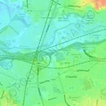
Carte topographique Micker Brook
Carte interactive
Cliquez sur la carte pour afficher l’altitude.
À propos de cette carte
Nom : Carte topographique Micker Brook, altitude, relief.
Altitude moyenne : 42 m
Altitude minimum : 29 m
Altitude maximum : 71 m
Autres cartes topographiques
Cliquez sur une carte pour visualiser sa topographie, son altitude et son relief.
Mellor
United Kingdom > England > Stockport
Mellor, Stockport, Greater Manchester, England, SK6 5PJ, United Kingdom
Altitude moyenne : 170 m
River Mersey
United Kingdom > England > Stockport
River Mersey, Stockport, Greater Manchester, North West England, England, SK1 1XU, United Kingdom
Altitude moyenne : 68 m
Ridge End
United Kingdom > England > Stockport > Marpleridge
Ridge End, Marpleridge, Stockport, Greater Manchester, England, SK6 7JZ, United Kingdom
Altitude moyenne : 164 m
Marple Bridge
United Kingdom > England > Stockport
Marple Bridge, Stockport, Greater Manchester, England, SK6 5BT, United Kingdom
Altitude moyenne : 147 m
Woodford
United Kingdom > England > Stockport
Woodford, Stockport, Greater Manchester, England, SK7 1PP, United Kingdom
Altitude moyenne : 87 m
Hawk Green
United Kingdom > England > Stockport > Hawk Green
Hawk Green, Stockport, Greater Manchester, North West England, England, SK6 7HU, United Kingdom
Altitude moyenne : 144 m
Compstall
United Kingdom > England > Stockport > Compstall
Compstall, Stockport, Greater Manchester, North West England, England, SK6 5HU, United Kingdom
Altitude moyenne : 151 m
Carr Wood
United Kingdom > England > Stockport
Carr Wood, Carrwood Road, Kitt's Moss, Stockport, Greater Manchester, North West England, England, SK7 3EL, United Kingdom
Altitude moyenne : 77 m