
Faire un don
Équipez-vous pour votre prochaine aventure :
En tant que Partenaire Amazon, ce site perçoit une commission sur les achats éligibles sans surcoût pour vous.
Carte topographique River Clyde
Cliquez sur la carte pour afficher l’altitude.
Faire un don
Équipez-vous pour votre prochaine aventure :
En tant que Partenaire Amazon, ce site perçoit une commission sur les achats éligibles sans surcoût pour vous.
À propos de cette carte
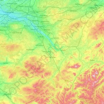
Nom : Carte topographique River Clyde, altitude, relief.
Lieu : River Clyde, South Lanarkshire, Scotland, United Kingdom (55.40684 -4.46261 55.92070 -3.55833)
Altitude moyenne : 245 m
Altitude minimum : 1 m
Altitude maximum : 727 m
Faire un don
Équipez-vous pour votre prochaine aventure :
En tant que Partenaire Amazon, ce site perçoit une commission sur les achats éligibles sans surcoût pour vous.
Autres cartes topographiques
Cliquez sur une carte pour visualiser sa topographie, son altitude et son relief.
East Kilbride
United Kingdom > Scotland > South Lanarkshire
These findings have found further support through ongoing research indicating that many East Kilbride Cairns first noticed by the Reverend David Ure in his History of Rutherglen and East Kilbride (1793), are embedded, alongside other monuments, into a ritual landscape related to ancestor cults and…
Altitude moyenne : 174 m
Avon Gorge
United Kingdom > Scotland > South Lanarkshire > Larkhall > Morgan Glen
Altitude moyenne : 118 m
Faire un don
Équipez-vous pour votre prochaine aventure :
En tant que Partenaire Amazon, ce site perçoit une commission sur les achats éligibles sans surcoût pour vous.
Avon Gorge
United Kingdom > Scotland > South Lanarkshire > Larkhall > Morgan Glen
Altitude moyenne : 118 m
Faire un don
Équipez-vous pour votre prochaine aventure :
En tant que Partenaire Amazon, ce site perçoit une commission sur les achats éligibles sans surcoût pour vous.
Faire un don
Équipez-vous pour votre prochaine aventure :
En tant que Partenaire Amazon, ce site perçoit une commission sur les achats éligibles sans surcoût pour vous.
Biggar
United Kingdom > Scotland > South Lanarkshire
Biggar has an oceanic climate (Köppen: Cfb). Camps Reservoir is a nearby weather station situated at an elevation of 295 m (968 ft).
Altitude moyenne : 254 m
Faire un don
Équipez-vous pour votre prochaine aventure :
En tant que Partenaire Amazon, ce site perçoit une commission sur les achats éligibles sans surcoût pour vous.
Faire un don
Équipez-vous pour votre prochaine aventure :
En tant que Partenaire Amazon, ce site perçoit une commission sur les achats éligibles sans surcoût pour vous.
Drumclog
United Kingdom > Scotland > South Lanarkshire
Drumclog is a small village in South Lanarkshire, Parish of Avendale and Drumclog, Scotland. The settlement is situated on the A71, between Caldermill and Priestland in East Ayrshire at an elevation of 197 metres (646 feet) and about five miles (eight kilometres) west of Strathaven.
Altitude moyenne : 216 m
Faire un don
Équipez-vous pour votre prochaine aventure :
En tant que Partenaire Amazon, ce site perçoit une commission sur les achats éligibles sans surcoût pour vous.
Low Banks
United Kingdom > Scotland > South Lanarkshire > Lamington > Millhill
Altitude moyenne : 263 m
Faire un don
Équipez-vous pour votre prochaine aventure :
En tant que Partenaire Amazon, ce site perçoit une commission sur les achats éligibles sans surcoût pour vous.
Faire un don
Équipez-vous pour votre prochaine aventure :
En tant que Partenaire Amazon, ce site perçoit une commission sur les achats éligibles sans surcoût pour vous.
Faire un don
Équipez-vous pour votre prochaine aventure :
En tant que Partenaire Amazon, ce site perçoit une commission sur les achats éligibles sans surcoût pour vous.
East Kilbride
United Kingdom > Scotland > South Lanarkshire
The earliest-known evidence of occupation in the area dates as far back as the late Neolithic and Early Bronze Age, as archaeological investigation has demonstrated that burial cairns in the district began as ceremonial or ritual sites of burial during the Neolithic, with the use of cup-marked, and other…
Altitude moyenne : 174 m
Faire un don
Équipez-vous pour votre prochaine aventure :
En tant que Partenaire Amazon, ce site perçoit une commission sur les achats éligibles sans surcoût pour vous.
Langlands Moss Local Nature Reserve
United Kingdom > Scotland > South Lanarkshire > East Kilbride
Altitude moyenne : 204 m
Faire un don
Équipez-vous pour votre prochaine aventure :
En tant que Partenaire Amazon, ce site perçoit une commission sur les achats éligibles sans surcoût pour vous.
Rigside
United Kingdom > Scotland > South Lanarkshire
Drumalbin is a Met Office weather station near Rigside, situated at an elevation of 245 m.
Altitude moyenne : 244 m
Faire un don
Équipez-vous pour votre prochaine aventure :
En tant que Partenaire Amazon, ce site perçoit une commission sur les achats éligibles sans surcoût pour vous.
Clyde Valley Family Park's Island
United Kingdom > Scotland > South Lanarkshire > Hazelbank > Birkhill
Altitude moyenne : 119 m
Craignethan Castle
United Kingdom > Scotland > South Lanarkshire > Crossford > Tillietudlem
Altitude moyenne : 121 m
Faire un don
Équipez-vous pour votre prochaine aventure :
En tant que Partenaire Amazon, ce site perçoit une commission sur les achats éligibles sans surcoût pour vous.
Langlands Moss Lowland Raised Peatbog
United Kingdom > Scotland > South Lanarkshire > East Kilbride
Altitude moyenne : 204 m
Faire un don
Équipez-vous pour votre prochaine aventure :
En tant que Partenaire Amazon, ce site perçoit une commission sur les achats éligibles sans surcoût pour vous.
Tinto Hill
United Kingdom > Scotland > South Lanarkshire
At the summit sits "Tinto Cairn", and with a diameter of 45 m (148 ft) and a height of 6 m (20 ft) it is one of the largest Bronze Age round cairns in Scotland, most of which are found at lower elevations.
Altitude moyenne : 436 m
Faire un don
Équipez-vous pour votre prochaine aventure :
En tant que Partenaire Amazon, ce site perçoit une commission sur les achats éligibles sans surcoût pour vous.
Faire un don
Équipez-vous pour votre prochaine aventure :
En tant que Partenaire Amazon, ce site perçoit une commission sur les achats éligibles sans surcoût pour vous.
Faire un don
Équipez-vous pour votre prochaine aventure :
En tant que Partenaire Amazon, ce site perçoit une commission sur les achats éligibles sans surcoût pour vous.
Faire un don
Équipez-vous pour votre prochaine aventure :
En tant que Partenaire Amazon, ce site perçoit une commission sur les achats éligibles sans surcoût pour vous.
East Kilbride
United Kingdom > Scotland > South Lanarkshire
The earliest-known evidence of occupation in the area dates as far back as the late Neolithic and Early Bronze Age, as archaeological investigation has demonstrated that burial cairns in the district began as ceremonial or ritual sites of burial during the Neolithic, with the use of cup-marked, and other…
Altitude moyenne : 174 m
Faire un don
Équipez-vous pour votre prochaine aventure :
En tant que Partenaire Amazon, ce site perçoit une commission sur les achats éligibles sans surcoût pour vous.
Trough Linn Woodlands Project
United Kingdom > Scotland > South Lanarkshire > East Kilbride
Altitude moyenne : 185 m
Faire un don
Équipez-vous pour votre prochaine aventure :
En tant que Partenaire Amazon, ce site perçoit une commission sur les achats éligibles sans surcoût pour vous.
East Kilbride
United Kingdom > Scotland > South Lanarkshire
The earliest-known evidence of occupation in the area dates as far back as the late Neolithic and Early Bronze Age, as archaeological investigation has demonstrated that burial cairns in the district began as ceremonial or ritual sites of burial during the Neolithic, with the use of cup-marked, and other…
Altitude moyenne : 174 m