
Carte topographique Crickhowell
Carte interactive
Cliquez sur la carte pour afficher l’altitude.
À propos de cette carte
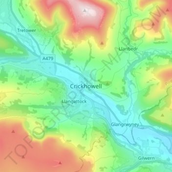
Nom : Carte topographique Crickhowell, altitude, relief.
Lieu : Crickhowell, Powys, Wales, NP8 1BB, United Kingdom (51.81911 -3.17836 51.89911 -3.09836)
Altitude moyenne : 253 m
Altitude minimum : 49 m
Altitude maximum : 701 m
Autres cartes topographiques
Cliquez sur une carte pour visualiser sa topographie, son altitude et son relief.
Brecon Beacons National Park
United Kingdom > Wales > Powys
Brecon Beacons National Park, officially named Bannau Brycheiniog National Park (Welsh pronunciation), is a national park in Wales. It is named after the Brecon Beacons (Welsh: Bannau Brycheiniog), the mountain range at its centre. The national park includes the highest mountain in South Wales, Pen y Fan,…
Altitude moyenne : 270 m
Grwyne Fawr Reservoir
United Kingdom > Wales > Powys
By the end of the 19th-century there were serious water shortages in the western parts of the historic county of Monmouthshire. The area had seen a massive population increase as a result of the steel and coal industries but the supply of water to the area was complicated due to its high altitude. A site for a…
Altitude moyenne : 619 m
River Severn
United Kingdom > Wales > Powys > Welshpool
The River Severn (Welsh: Afon Hafren, pronounced [ˈavɔn ˈhavrɛn]), at 220 miles (354 km) long, is the longest river in Great Britain. It is also the river with the most voluminous flow of water by far in all of England and Wales, with an average flow rate of 107 m3/s (3,800 cu ft/s) at Apperley,…
Altitude moyenne : 92 m
Brecon Beacons National Park
United Kingdom > Wales > Powys
Brecon Beacons National Park, officially named Bannau Brycheiniog National Park (Welsh pronunciation), is a national park in Wales. It is named after the Brecon Beacons (Welsh: Bannau Brycheiniog), the mountain range at its centre. The national park includes the highest mountain in South Wales, Pen y Fan,…
Altitude moyenne : 270 m
Craig Cerrig Gleisiad a Fan Frynych National Nature Reserve
United Kingdom > Wales > Powys
Altitude moyenne : 473 m
Llangorse Lake
United Kingdom > Wales > Powys > Llangors
The lake is a Site of Special Scientific Interest (SSSI) and has long been regarded as a place where fish and birds are found in unusually high numbers. Gerald of Wales (Giraldus Cambrensis) mentioned the abundance of waterfowl in his topographical work, The Description of Wales in the 12th century. It is a…
Altitude moyenne : 177 m