
Carte topographique Mount Mitchell
Carte interactive
Cliquez sur la carte pour afficher l’altitude.
À propos de cette carte
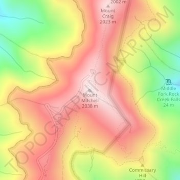
Nom : Carte topographique Mount Mitchell, altitude, relief.
Lieu : Mount Mitchell, Yancey County, North Carolina, United States (35.76491 -82.26517 35.76501 -82.26507)
Altitude moyenne : 1’743 m
Altitude minimum : 1’355 m
Altitude maximum : 2’019 m
Mount Mitchell, known in Cherokee as Attakulla, is the highest peak of the Appalachian Mountains and the highest peak in mainland eastern North America. It is located near Burnsville in Yancey County, North Carolina in the Black Mountain subrange of the Appalachians about 19 miles (31 km) northeast of Asheville. It is protected by Mount Mitchell State Park and surrounded by the Pisgah National Forest. Mount Mitchell's elevation is 6,684 feet (2,037 m) above sea level.
Autres cartes topographiques
Cliquez sur une carte pour visualiser sa topographie, son altitude et son relief.
Appalachian Mountains
United States > North Carolina > Yancey County
Appalachian Mountains, Yancey County, North Carolina, United States
Altitude moyenne : 1’463 m
Burnsville
United States > North Carolina > Yancey County
Burnsville, Yancey County, North Carolina, United States
Altitude moyenne : 882 m
Mitchell Ridge
United States > North Carolina > Yancey County
Mitchell Ridge, Yancey County, North Carolina, United States
Altitude moyenne : 1’517 m
Cane River
United States > North Carolina > Yancey County > Low Gap
Cane River, Low Gap, Yancey County, North Carolina, 28714, United States
Altitude moyenne : 944 m
Cane River
United States > North Carolina > Yancey County > Eskota
Cane River, Eskota, Yancey County, North Carolina, United States
Altitude moyenne : 1’154 m
Lost Cove
United States > North Carolina > Yancey County > Lost Cove
Lost Cove, Yancey County, North Carolina, United States
Altitude moyenne : 852 m