
Carte topographique Crown Point
Carte interactive
Cliquez sur la carte pour afficher l’altitude.
À propos de cette carte
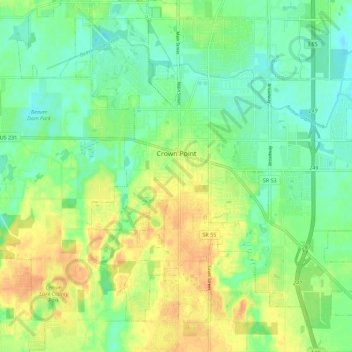
Nom : Carte topographique Crown Point, altitude, relief.
Lieu : Crown Point, Lake County, Indiana, 46307, United States (41.36921 -87.39758 41.45373 -87.29672)
Altitude moyenne : 220 m
Altitude minimum : 204 m
Altitude maximum : 240 m
Autres cartes topographiques
Cliquez sur une carte pour visualiser sa topographie, son altitude et son relief.
Center Township
United States > Indiana > Lake County
Center Township, Lake County, Indiana, 46307, United States
Altitude moyenne : 220 m
Three Rivers Park Lake
United States > Indiana > Lake County > Lake Station
Three Rivers Park Lake, Lake Station, Hobart Township, Lake County, Indiana, United States
Altitude moyenne : 186 m
Miller
United States > Indiana > Lake County > Gary
Miller, Miller Beach, Gary, Calumet Township, Lake County, Indiana, 46403, United States
Altitude moyenne : 186 m
Lowell
United States > Indiana > Lake County
Lowell, Lake County, Indiana, 46356, United States
Altitude moyenne : 214 m
Illinoi
United States > Indiana > Lake County
Illinoi, Lake County, Indiana, United States
Altitude moyenne : 192 m
Grand Calumet River
United States > Indiana > Lake County > Gary
Grand Calumet River, Gary, Thornton Township, Lake County, Indiana, United States
Altitude moyenne : 180 m
Merrillville
United States > Indiana > Lake County
Merrillville, Ross Township, Lake County, Indiana, 46410, United States
Altitude moyenne : 204 m
Griffith
United States > Indiana > Lake County
Griffith, Lake County, Indiana, 46319, United States
Altitude moyenne : 190 m
Cedar Lake
United States > Indiana > Lake County
Cedar Lake, Lake County, Indiana, 46303, United States
Altitude moyenne : 223 m
New Chicago
United States > Indiana > Lake County
New Chicago, Lake County, Indiana, United States
Altitude moyenne : 192 m
Schererville
United States > Indiana > Lake County
Schererville, Lake County, Indiana, 46375, United States
Altitude moyenne : 203 m
Lake Station
United States > Indiana > Lake County
Lake Station, Hobart Township, Lake County, Indiana, 46405, United States
Altitude moyenne : 189 m
Highland
United States > Indiana > Lake County
Highland, Lake County, Indiana, 46322, United States
Altitude moyenne : 188 m
Winfield
United States > Indiana > Lake County
Winfield, Lake County, Indiana, United States
Altitude moyenne : 216 m
St. John
United States > Indiana > Lake County
St. John, Lake County, Indiana, 46373, United States
Altitude moyenne : 213 m
Gary
United States > Indiana > Lake County
Gary, Calumet Township, Lake County, Indiana, United States
Altitude moyenne : 185 m
Munster
United States > Indiana > Lake County
Munster, Lake County, Indiana, 46321, United States
Altitude moyenne : 187 m
Hammond
United States > Indiana > Lake County > Hammond > Hammond
Hammond, Lake County, Indiana, 46324, United States
Altitude moyenne : 184 m
Gary
United States > Indiana > Lake County > Gary
Gary, Lake County, Indiana, 46402, United States
Altitude moyenne : 187 m
Dyer
United States > Indiana > Lake County
Dyer, Lake County, Indiana, 46311, United States
Altitude moyenne : 196 m
East Chicago
United States > Indiana > Lake County
East Chicago, Lake County, Indiana, 46312, United States
Altitude moyenne : 179 m
Hammond
United States > Indiana > Lake County
Hammond, Lake County, Indiana, United States
Altitude moyenne : 180 m
Hobart
United States > Indiana > Lake County
Hobart, Hobart Township, Lake County, Indiana, 46342, United States
Altitude moyenne : 197 m
Whiting
United States > Indiana > Lake County
Whiting, Lake County, Indiana, 46394, United States
Altitude moyenne : 178 m