

Carte topographique Hillsboro
Cliquez sur la carte pour afficher l’altitude.
Hillsboro
Hillsboro is located at 45°31′N 122°59′W / 45.517°N 122.983°W / 45.517; -122.983 (Hillsboro, Oregon). The United States Census Bureau reports the city has a total area of 21.6 square miles (55.9 km2), all of which is land. In 2013, Hillsboro itself reported an area of 23.88 square miles (61.8 km2), equivalent to 15,283 acres (61.8 km2). The city is located in the Tualatin Valley, and the Tualatin River forms part of the southern city limits. The city's terrain is fairly level, consistent with an agricultural past and the farms still in operation. Hillsboro is about 17 miles (27 km) west of Portland and immediately west of Beaverton, at an elevation of 194 feet (59 m) above sea level. In addition to the Tualatin River, streams include Dairy Creek, McKay Creek, Rock Creek, Dawson Creek, and Turner Creek. Neighboring communities in addition to Beaverton are Aloha, Cornelius, Glencoe, North Plains, Reedville, Scholls, and West Union.
À propos de cette carte
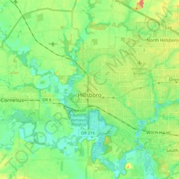
Nom : Carte topographique Hillsboro, altitude, relief.
Lieu : Hillsboro, Washington County, Oregon, United States (45.47636 -123.01181 45.57652 -122.85954)
Altitude moyenne : 53 m
Altitude minimum : 33 m
Altitude maximum : 93 m
Autres cartes topographiques
Cliquez sur une carte pour visualiser sa topographie, son altitude et son relief.



Vern Galaway Memorial Park
United States > Oregon > Washington County > North Plains
Altitude moyenne : 56 m