Géolocaliser

Carte topographique Mount Rushmore

Carte interactive

Cliquez sur la carte pour afficher l’altitude.

À propos de cette carte

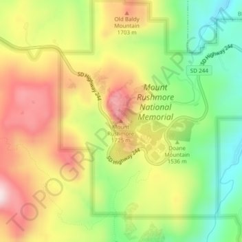
Nom : Carte topographique Mount Rushmore, altitude, relief.

Lieu : Mount Rushmore, Pennington County, South Dakota, 57751, United States (43.87868 -103.45924 43.87878 -103.45914)

Altitude moyenne : 1’562 m

Altitude minimum : 1’367 m

Altitude maximum : 1’766 m

Mount Rushmore National Memorial is centered on a colossal sculpture carved into the granite face of Mount Rushmore (Lakota Tȟuŋkášila Šákpe, or Six Grandfathers) in the Black Hills in Keystone, South Dakota. Sculptor Gutzon Borglum created the sculpture's design and oversaw the project's execution from 1927 to 1941 with the help of his son, Lincoln Borglum. The sculpture features the 60-foot (18 m) heads of Presidents George Washington (1732–1799), Thomas Jefferson (1743–1826), Theodore Roosevelt (1858–1919) and Abraham Lincoln (1809–1865), as recommended by Borglum. The four presidents were chosen to represent the nation's birth, growth, development and preservation, respectively. The memorial park covers 1,278 acres (2.00 sq mi; 5.17 km2) and the actual mountain has an elevation of 5,725 feet (1,745 m) above sea level.

Autres cartes topographiques

Cliquez sur une carte pour visualiser sa topographie, son altitude et son relief.

Rapid City

United States > South Dakota > Pennington County

Rapid City, Pennington County, South Dakota, United States

Altitude moyenne : 1’068 m

Madison

United States > South Dakota > Lake County

Madison, Lakeview Township, Lake County, South Dakota, United States

Altitude moyenne : 516 m

Sioux Falls

United States > South Dakota > Minnehaha County

Sioux Falls, Sioux Falls Township, Minnehaha County, South Dakota, United States

Altitude moyenne : 445 m

Canton

United States > South Dakota > Lincoln County

Canton, Canton Township, Lincoln County, South Dakota, 57013, United States

Altitude moyenne : 392 m

Stockade Lake

United States > South Dakota > Custer County

Stockade Lake, Custer County, South Dakota, United States

Altitude moyenne : 1’616 m

Westport

United States > South Dakota > Brown County

Westport, Westport Township, Brown County, South Dakota, United States

Altitude moyenne : 413 m

Kennedy Township

United States > South Dakota > Charles Mix County

Kennedy Township, Charles Mix County, South Dakota, United States

Altitude moyenne : 437 m

Custer State Park

United States > South Dakota > Custer County

Custer State Park, Custer County, South Dakota, United States

Altitude moyenne : 1’413 m

Red Shirt

United States > South Dakota > Oglala Lakota County

Red Shirt, White Clay District, Oglala Lakota County, South Dakota, United States

Altitude moyenne : 845 m

Lake Poinsett

United States > South Dakota > Hamlin County

Lake Poinsett, Norden Township, Hamlin County, South Dakota, United States

Altitude moyenne : 506 m

Spearfish

United States > South Dakota > Lawrence County

Spearfish, Lawrence County, South Dakota, United States

Altitude moyenne : 1’171 m

Alsville

United States > South Dakota > Hamlin County

Alsville, Norden Township, Hamlin County, South Dakota, United States

Altitude moyenne : 513 m

Aurora Township

United States > South Dakota > Brookings County

Aurora Township, Brookings County, South Dakota, 57002, United States

Altitude moyenne : 503 m

Brookings

United States > South Dakota > Brookings County

Brookings, Brookings Township, Brookings County, South Dakota, United States

Altitude moyenne : 495 m

Savoy

United States > South Dakota > Lawrence County

Savoy, Lawrence County, South Dakota, United States

Altitude moyenne : 1’665 m

Black Hills

United States > South Dakota > Pennington County

Black Hills, Pennington County, South Dakota, United States

Altitude moyenne : 1’894 m

Mitchell

United States > South Dakota > Davison County

Mitchell, Mitchell Township, Davison County, South Dakota, 57301, United States

Altitude moyenne : 395 m

Terry Peak

United States > South Dakota > Lawrence County

Terry Peak, Lawrence County, South Dakota, United States

Altitude moyenne : 1’940 m

La Bolt

United States > South Dakota > Grant County

La Bolt, Grant County, South Dakota, United States

Altitude moyenne : 418 m

Big Stone City

United States > South Dakota > Grant County

Big Stone City, Grant County, South Dakota, United States

Altitude moyenne : 314 m

Strandburg

United States > South Dakota > Grant County

Strandburg, Grant County, South Dakota, United States

Altitude moyenne : 512 m

Twin Brooks

United States > South Dakota > Grant County

Twin Brooks, Grant County, South Dakota, United States

Altitude moyenne : 385 m

Badlands National Park

United States > South Dakota > Oglala Lakota County

Badlands National Park, Oglala Lakota County, South Dakota, 57750, United States

Altitude moyenne : 848 m

Mount Rushmore National Memorial

United States > South Dakota > Pennington County

Mount Rushmore National Memorial, Pennington County, South Dakota, United States

Altitude moyenne : 1’528 m

Deadwood

United States > South Dakota > Lawrence County

Deadwood, Lawrence County, South Dakota, 57732, United States

Altitude moyenne : 1’511 m

Brandon

United States > South Dakota > Minnehaha County

Brandon, Brandon Township, Minnehaha County, South Dakota, 57005, United States

Altitude moyenne : 415 m

Buffalo

United States > South Dakota > Harding County

Buffalo, Harding County, South Dakota, 57720, United States

Altitude moyenne : 885 m

Phillip Jung Number 1 Dam

United States > South Dakota > Corson County

Phillip Jung Number 1 Dam, Rock Creek District, Corson County, South Dakota, United States

Altitude moyenne : 671 m

Opdahl Township

United States > South Dakota > Hamlin County

Opdahl Township, Hamlin County, South Dakota, United States

Altitude moyenne : 526 m

Brooking Municipal Utilitys

United States > South Dakota > Brookings County > Brookings

Brooking Municipal Utilitys, Brookings, Brookings Township, Brookings County, South Dakota, United States

Altitude moyenne : 492 m

Brookings County

United States > South Dakota

Brookings County, South Dakota, United States

Altitude moyenne : 525 m

Blumengard Hutterite Colony

United States > South Dakota > Faulk County

Blumengard Hutterite Colony, Faulk County, South Dakota, United States

Altitude moyenne : 491 m

Irene

United States > South Dakota > Yankton County

Irene, Marindahl Township, Yankton County, South Dakota, United States

Altitude moyenne : 432 m

Arlington

United States > South Dakota > Kingsbury County

Arlington, Kingsbury County, South Dakota, United States

Altitude moyenne : 558 m

Mansfield

United States > South Dakota > Brown County

Mansfield, Brown County, South Dakota, 57460, United States

Altitude moyenne : 394 m

Wessington

United States > South Dakota > Beadle County

Wessington, Beadle County, South Dakota, United States

Altitude moyenne : 430 m

Iroquois

United States > South Dakota > Kingsbury County

Iroquois, Kingsbury County, South Dakota, 57353, United States

Altitude moyenne : 428 m

North Sioux City

United States > South Dakota > Union County

North Sioux City, Big Sioux Township, Union County, South Dakota, United States

Altitude moyenne : 348 m

Philip

United States > South Dakota > Haakon County

Philip, Haakon County, South Dakota, United States

Altitude moyenne : 674 m

Colonial Pine Hills

United States > South Dakota > Pennington County

Colonial Pine Hills, Pennington County, South Dakota, United States

Altitude moyenne : 1’232 m

Lennox

United States > South Dakota > Lincoln County

Lennox, Perry Township, Lincoln County, South Dakota, United States

Altitude moyenne : 408 m

Highmore

United States > South Dakota > Hyde County

Highmore, Hyde County, South Dakota, United States

Altitude moyenne : 573 m

Groton

United States > South Dakota > Brown County

Groton, Brown County, South Dakota, 57445, United States

Altitude moyenne : 397 m

Lake Andes

United States > South Dakota > Charles Mix County

Lake Andes, Charles Mix County, South Dakota, 57356, United States

Altitude moyenne : 448 m

Wagner

United States > South Dakota > Charles Mix County

Wagner, Lawrence Township, Charles Mix County, South Dakota, 57380, United States

Altitude moyenne : 443 m

Plankinton

United States > South Dakota > Aurora County

Plankinton, Aurora County, South Dakota, 57368, United States

Altitude moyenne : 465 m

Springfield

United States > South Dakota > Bon Homme County

Springfield, Bon Homme County, South Dakota, United States

Altitude moyenne : 394 m

Black Hawk

United States > South Dakota

Black Hawk, South Dakota, 57718, United States

Altitude moyenne : 1’088 m

Brandon Township

United States > South Dakota > Minnehaha County

Brandon Township, Minnehaha County, South Dakota, United States

Altitude moyenne : 428 m

Flandreau Township

United States > South Dakota > Moody County

Flandreau Township, Moody County, South Dakota, 57028, United States

Altitude moyenne : 488 m