
Carte topographique Clark Fork
Carte interactive
Cliquez sur la carte pour afficher l’altitude.
À propos de cette carte
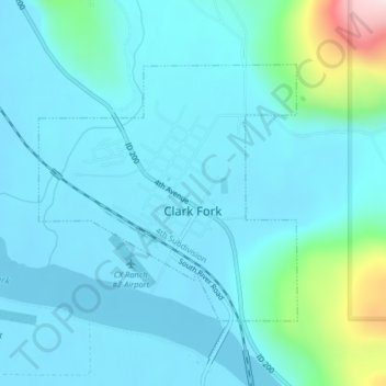
Nom : Carte topographique Clark Fork, altitude, relief.
Lieu : Clark Fork, Bonner County, Idaho, United States (48.13748 -116.19191 48.15545 -116.16474)
Altitude moyenne : 681 m
Altitude minimum : 625 m
Altitude maximum : 1’040 m
Clark Fork is located at 48°8′50″N 116°10′42″W / 48.14722°N 116.17833°W / 48.14722; -116.17833 (48.147180, -116.178270), at an elevation of 2,090 feet (637 m) above sea level. The town is situated on the Clark Fork River, on the eastern shores of Lake Pend Oreille. in the northern panhandle of the state. According to the United States Census Bureau, the city has a total area of 0.92 square miles (2.38 km2), all of it land. The Lightning Creek passes just north and west of the town.
Autres cartes topographiques
Cliquez sur une carte pour visualiser sa topographie, son altitude et son relief.
Sandpoint
United States > Idaho > Bonner County
Sandpoint, Bonner County, Idaho, United States
Altitude moyenne : 658 m
Hope
United States > Idaho > Bonner County
Hope, Bonner County, Idaho, United States
Altitude moyenne : 763 m
Dover
United States > Idaho > Bonner County
Dover, Bonner County, Idaho, 83825, United States
Altitude moyenne : 680 m
Priest Lake
United States > Idaho > Bonner County
Priest Lake, Bonner County, Idaho, United States
Altitude moyenne : 1’123 m
Priest River
United States > Idaho > Bonner County
Priest River, Bonner County, Idaho, United States
Altitude moyenne : 742 m
Sagle
United States > Idaho > Bonner County
Sagle, Bonner County, Idaho, 83860, United States
Altitude moyenne : 692 m
Pend Oreille River
United States > Idaho > Bonner County > Oldtown
Pend Oreille River, Oldtown, Bonner County, Idaho, 83822, United States
Altitude moyenne : 657 m
Careywood
United States > Idaho > Bonner County
Careywood, Bonner County, Idaho, United States
Altitude moyenne : 740 m
Ponderay
United States > Idaho > Bonner County
Ponderay, Bonner County, Idaho, 83852, United States
Altitude moyenne : 652 m
Cedar Creek
United States > Idaho > Bonner County
Cedar Creek, Bonner County, Idaho, United States
Altitude moyenne : 748 m
Kootenai
United States > Idaho > Bonner County
Kootenai, Bonner County, Idaho, 83840, United States
Altitude moyenne : 641 m
Sandpoint
United States > Idaho > Bonner County > Sandpoint
Sandpoint, Bonner County, Idaho, 83852, United States
Altitude moyenne : 687 m
Blanchard
United States > Idaho > Bonner County
Blanchard, Bonner County, Idaho, 83804, United States
Altitude moyenne : 718 m