
Carte topographique Cranham
Carte interactive
Cliquez sur la carte pour afficher l’altitude.
À propos de cette carte
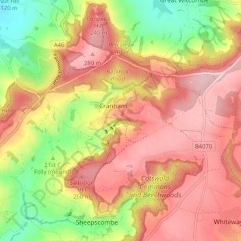
Nom : Carte topographique Cranham, altitude, relief.
Altitude moyenne : 199 m
Altitude minimum : 68 m
Altitude maximum : 295 m
Autres cartes topographiques
Cliquez sur une carte pour visualiser sa topographie, son altitude et son relief.
Cranham
United Kingdom > England > Stroud > Cranham
Cranham, Stroud, Gloucestershire, South West England, England, GL4 8HP, United Kingdom
Altitude moyenne : 196 m