
Carte topographique Cumberland
Carte interactive
Cliquez sur la carte pour afficher l’altitude.
À propos de cette carte
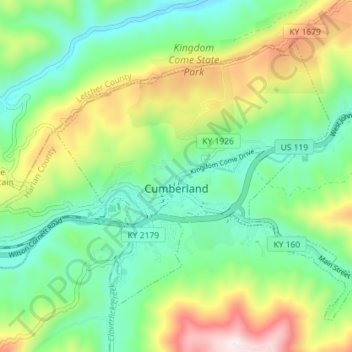
Nom : Carte topographique Cumberland, altitude, relief.
Lieu : Cumberland, Harlan County, Kentucky, 40823, United States (36.95876 -83.02875 37.00153 -82.95724)
Altitude moyenne : 591 m
Altitude minimum : 362 m
Altitude maximum : 1’052 m
Cumberland is located in northeastern Harlan County at 36°58′37″N 82°59′15″W / 36.97694°N 82.98750°W / 36.97694; -82.98750 (36.977016, -82.987434) in the valley of the Poor Fork of the Cumberland River, where it is joined by Looney Creek from the southeast and Cloverlick Creek from the south. The city limits extend to the north up to the crest of Pine Mountain, which forms the Letcher County line. Elevations within the city range from 1,400 feet (430 m) above sea level along the Poor Fork on the west side of town to 2,700 feet (820 m) atop Pine Mountain.
Autres cartes topographiques
Cliquez sur une carte pour visualiser sa topographie, son altitude et son relief.
Pathfork
United States > Kentucky > Harlan County
Pathfork, Harlan County, Kentucky, 40863, United States
Altitude moyenne : 534 m
Lenarue
United States > Kentucky > Harlan County
Lenarue, Harlan County, Kentucky, 40818, United States
Altitude moyenne : 519 m
Bardo
United States > Kentucky > Harlan County
Bardo, Harlan County, Kentucky, 40830, United States
Altitude moyenne : 634 m
Holmes Mill
United States > Kentucky > Harlan County
Holmes Mill, Harlan County, Kentucky, 40843, United States
Altitude moyenne : 758 m
Putney
United States > Kentucky > Harlan County
Putney, Harlan County, Kentucky, 40865, United States
Altitude moyenne : 601 m
Pansy
United States > Kentucky > Harlan County
Pansy, Harlan County, Kentucky, 40830, United States
Altitude moyenne : 602 m
Alva
United States > Kentucky > Harlan County
Alva, Harlan County, Kentucky, 40863, United States
Altitude moyenne : 652 m
Wallins Creek
United States > Kentucky > Harlan County
Wallins Creek, Harlan County, Kentucky, United States
Altitude moyenne : 416 m
Lejunior
United States > Kentucky > Harlan County
Lejunior, Harlan County, Kentucky, 40865, United States
Altitude moyenne : 585 m
Pine Mountain
United States > Kentucky > Harlan County
Pine Mountain, Harlan County, Kentucky, United States
Altitude moyenne : 536 m
Three Point
United States > Kentucky > Harlan County
Three Point, Harlan County, Kentucky, 40815, United States
Altitude moyenne : 475 m
Louellen
United States > Kentucky > Harlan County
Louellen, Harlan County, Kentucky, 40849, United States
Altitude moyenne : 698 m
Kenvir
United States > Kentucky > Harlan County
Kenvir, Harlan County, Kentucky, 40847, United States
Altitude moyenne : 642 m
Ages
United States > Kentucky > Harlan County
Ages, Harlan County, Kentucky, 40801, United States
Altitude moyenne : 587 m
Fresh Meadows
United States > Kentucky > Harlan County
Fresh Meadows, Harlan County, Kentucky, 40824, United States
Altitude moyenne : 462 m
Yancey
United States > Kentucky > Harlan County
Yancey, Harlan County, Kentucky, 40830, United States
Altitude moyenne : 651 m
Big Laurel
United States > Kentucky > Harlan County
Big Laurel, Harlan County, Kentucky, 40808, United States
Altitude moyenne : 574 m
Cawood
United States > Kentucky > Harlan County
Cawood, Harlan County, Kentucky, 40818, United States
Altitude moyenne : 498 m
South Wallins
United States > Kentucky > Harlan County > South Wallins
South Wallins, Harlan County, Kentucky, 40873, United States
Altitude moyenne : 528 m
Dayhoit
United States > Kentucky > Harlan County
Dayhoit, Harlan County, Kentucky, 40824, United States
Altitude moyenne : 462 m
Molus
United States > Kentucky > Harlan County
Molus, Harlan County, Kentucky, 40819, United States
Altitude moyenne : 467 m
Closplint
United States > Kentucky > Harlan County
Closplint, Harlan County, Kentucky, 40927, United States
Altitude moyenne : 716 m
Loyall
United States > Kentucky > Harlan County
Loyall, Harlan County, Kentucky, 40854, United States
Altitude moyenne : 434 m
Benham
United States > Kentucky > Harlan County
Benham, Harlan County, Kentucky, 40807, United States
Altitude moyenne : 667 m
Totz
United States > Kentucky > Harlan County
Totz, Harlan County, Kentucky, 40870, United States
Altitude moyenne : 638 m
Bledsoe
United States > Kentucky > Harlan County
Bledsoe, Harlan County, Kentucky, 40810, United States
Altitude moyenne : 604 m
Creech
United States > Kentucky > Harlan County
Creech, Harlan County, Kentucky, United States
Altitude moyenne : 661 m
River Ridge
United States > Kentucky > Harlan County
River Ridge, Harlan County, Kentucky, 40828, United States
Altitude moyenne : 584 m
Evarts
United States > Kentucky > Harlan County
Evarts, Harlan County, Kentucky, United States
Altitude moyenne : 533 m
Baxter
United States > Kentucky > Harlan County
Baxter, Harlan County, Kentucky, 40806, United States
Altitude moyenne : 468 m
Coldiron
United States > Kentucky > Harlan County
Coldiron, Harlan County, Kentucky, 40819, United States
Altitude moyenne : 472 m
Lynch
United States > Kentucky > Harlan County
Lynch, Harlan County, Kentucky, United States
Altitude moyenne : 770 m
Divide
United States > Kentucky > Harlan County
Divide, Harlan County, Kentucky, 40865, United States
Altitude moyenne : 657 m
Cranks
United States > Kentucky > Harlan County
Cranks, Harlan County, Kentucky, 40820, United States
Altitude moyenne : 594 m
Harlan
United States > Kentucky > Harlan County
Harlan, Harlan County, Kentucky, 40831, United States
Altitude moyenne : 493 m
Harlan
United States > Kentucky > Harlan County > Harlan > Harlan
Harlan, Harlan County, Kentucky, 40831, United States
Altitude moyenne : 512 m