
Carte topographique Schofield Barracks
Carte interactive
Cliquez sur la carte pour afficher l’altitude.
À propos de cette carte
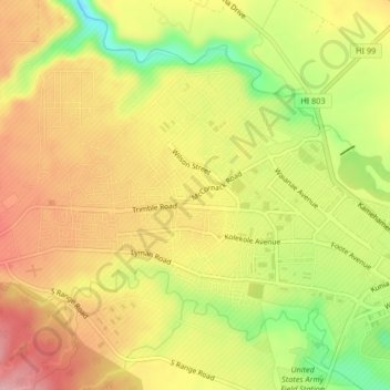
Nom : Carte topographique Schofield Barracks, altitude, relief.
Lieu : Schofield Barracks, Honolulu County, Hawaii, United States (21.47856 -158.08254 21.50819 -158.04103)
Altitude moyenne : 279 m
Altitude minimum : 182 m
Altitude maximum : 353 m
Schofield Barracks has a tropical savanna climate. Owing to a higher elevation, Schofield is slightly cooler year round than Honolulu, but is still well within the realms of a tropical climate. Precipitation patterns closely resemble those of mediterranean climates being found in mainland California, but its warm winters prevents the climate from being classified as such.
Autres cartes topographiques
Cliquez sur une carte pour visualiser sa topographie, son altitude et son relief.
Waipio Acres
United States > Hawaii > Honolulu County > Mililani
Waipio Acres, Mililani, Honolulu County, Hawaii, United States
Altitude moyenne : 230 m
Mililani Mauka
United States > Hawaii > Honolulu County > Mililani
Mililani Mauka, Mililani, Honolulu County, Hawaii, United States
Altitude moyenne : 254 m
Oʻahu Forest National Wildlife Refuge
United States > Hawaii > Honolulu County > Mililani
Oʻahu Forest National Wildlife Refuge, Mililani, Honolulu County, Hawaii, United States
Altitude moyenne : 456 m