
Carte topographique Humacao
Carte interactive
Cliquez sur la carte pour afficher l’altitude.
À propos de cette carte
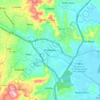
Nom : Carte topographique Humacao, altitude, relief.
Lieu : Humacao, Puerto Rico, 00792, United States (18.10918 -65.86501 18.18918 -65.78501)
Altitude moyenne : 78 m
Altitude minimum : 0 m
Altitude maximum : 312 m
Humacao is located in the southeast coast of Puerto Rico. It is bordered by the municipalities of Naguabo to the north, Yabucoa to the south, and Las Piedras to the west. The Atlantic Ocean borders the city in the east. Humacao is located in the region of the Eastern Coastal Plains, with most of its territory being flat. There are minor elevations to the southwest, like Candelero Hill, and northwest, like Mabú. Humacao's territory covers 45 square miles (117 km2). Two islands belong to Humacao: Cayo Santiago and Cayo Batata.