
Carte topographique Warren County
Carte interactive
Cliquez sur la carte pour afficher l’altitude.
À propos de cette carte
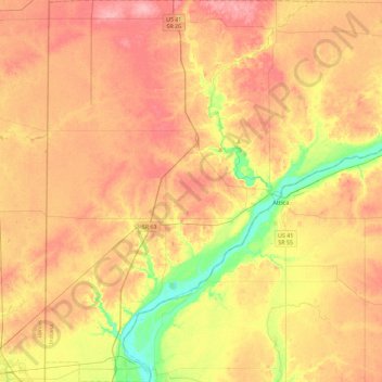
Nom : Carte topographique Warren County, altitude, relief.
Lieu : Warren County, Indiana, United States (40.13009 -87.53145 40.47865 -87.09193)
Altitude moyenne : 208 m
Altitude minimum : 147 m
Altitude maximum : 255 m
According to the 2010 census, the county has a total area of 366.40 square miles (949.0 km2), of which 364.68 square miles (944.5 km2) (or 99.53%) is land and 1.72 square miles (4.5 km2) (or 0.47%) is water. Elevations in the county range from 480 feet (150 m) above sea level where the Wabash River enters Vermillion County to 830 feet (250 m) in northeastern Prairie Township. The landscape consists mostly of flat or gently sloping moraine overlaying silty and loamy glacial till, except along the Wabash River where sand, gravel, sandstone and shale are exposed. Various forms of silt loam constitute most of the county's soil and are conducive to agriculture. Forests cover about 14% of the county, mainly around major waterways, and consist principally of deciduous hardwoods among which maple–beech and oak–hickory forests are the most common. The only coal mines in the county are located in the southeastern part of Steuben Township, near the Wabash River.
Autres cartes topographiques
Cliquez sur une carte pour visualiser sa topographie, son altitude et son relief.
Lafayette
United States > Indiana > Tippecanoe County
Lafayette, Tippecanoe County, Indiana, United States
Altitude moyenne : 193 m
Valparaiso
United States > Indiana > Porter County
Valparaiso, Porter County, Indiana, United States
Altitude moyenne : 235 m
West Lafayette
United States > Indiana > Tippecanoe County
West Lafayette, Tippecanoe County, Indiana, United States
Altitude moyenne : 192 m
Evansville
United States > Indiana > Vanderburgh County
Evansville, Vanderburgh County, Indiana, United States
Altitude moyenne : 122 m
Indianapolis
United States > Indiana > Indianapolis
Indianapolis, Marion County, Indiana, 46204, United States
Altitude moyenne : 241 m
Fort Wayne
United States > Indiana > Allen County
Fort Wayne, Allen County, Indiana, United States
Altitude moyenne : 246 m
Brekenridge Park
United States > Indiana > Warrick County > Boonville
Brekenridge Park, Boonville, Warrick County, Indiana, United States
Altitude moyenne : 126 m
Tippecanoe County
Tippecanoe County, Indiana, United States
Altitude moyenne : 211 m
Bloomington
United States > Indiana > Monroe County
Bloomington, Monroe County, Indiana, United States
Altitude moyenne : 241 m
Koontz Lake
United States > Indiana > Starke County
Koontz Lake, Starke County, Indiana, United States
Altitude moyenne : 221 m
Princeton
United States > Indiana > Gibson County
Princeton, Gibson County, Indiana, 47670, United States
Altitude moyenne : 149 m
South Bend
United States > Indiana > Saint Joseph County
South Bend, Saint Joseph County, Indiana, United States
Altitude moyenne : 236 m
Eagle Creek Park
United States > Indiana > Marion County > Indianapolis
Eagle Creek Park, Indianapolis, Marion County, Indiana, 46253, United States
Altitude moyenne : 256 m
Noblesville
United States > Indiana > Hamilton County
Noblesville, Hamilton County, Indiana, 46060, United States
Altitude moyenne : 249 m
Perkins
United States > Indiana > Newton County
Perkins, Newton County, Indiana, United States
Altitude moyenne : 211 m
Old Pekin
United States > Indiana > Washington County
Old Pekin, Washington County, Indiana, 47165, United States
Altitude moyenne : 229 m
Nineveh
United States > Indiana > Johnson County
Nineveh, Johnson County, Indiana, United States
Altitude moyenne : 238 m
Plymouth
United States > Indiana > Marshall County
Plymouth, Marshall County, Indiana, 46563, United States
Altitude moyenne : 247 m
Portage
United States > Indiana > Porter County
Portage, Porter County, Indiana, United States
Altitude moyenne : 190 m
Syracuse
United States > Indiana > Kosciusko County
Syracuse, Kosciusko County, Indiana, United States
Altitude moyenne : 267 m
Saint Joseph County
Saint Joseph County, Indiana, United States
Altitude moyenne : 239 m
Bluffton
United States > Indiana > Wells County
Bluffton, Wells County, Indiana, 46714, United States
Altitude moyenne : 254 m
Rock Hill
United States > Indiana > Spencer County
Rock Hill, Spencer County, Indiana, United States
Altitude moyenne : 124 m
York
United States > Indiana > Steuben County
York, Steuben County, Indiana, United States
Altitude moyenne : 320 m
Berlien
United States > Indiana > Steuben County
Berlien, Steuben County, Indiana, United States
Altitude moyenne : 312 m
Montpelier
United States > Indiana > Blackford County
Montpelier, Blackford County, Indiana, 47359, United States
Altitude moyenne : 266 m
Alvarado
United States > Indiana > Steuben County
Alvarado, Steuben County, Indiana, United States
Altitude moyenne : 292 m
Metz
United States > Indiana > Steuben County
Metz, Steuben County, Indiana, United States
Altitude moyenne : 297 m
Union City
United States > Indiana > Randolph County
Union City, Randolph County, Indiana, United States
Altitude moyenne : 333 m
Shirley
United States > Indiana > Hancock County
Shirley, Hancock County, Indiana, United States
Altitude moyenne : 312 m
Spring Grove
United States > Indiana > Wayne County
Spring Grove, Wayne County, Indiana, United States
Altitude moyenne : 300 m
Knightstown
United States > Indiana > Henry County
Knightstown, Henry County, Indiana, United States
Altitude moyenne : 285 m
Chain O'Lakes State Park
United States > Indiana > Noble County
Chain O'Lakes State Park, 9, Noble County, Indiana, United States
Altitude moyenne : 290 m
Switz City
United States > Indiana > Greene County
Switz City, Greene County, Indiana, 47465, United States
Altitude moyenne : 162 m
Middletown
United States > Indiana > Henry County
Middletown, Henry County, Indiana, United States
Altitude moyenne : 297 m
Cumberland
United States > Indiana > Hancock County
Cumberland, Hancock County, Indiana, United States
Altitude moyenne : 261 m
Springport
United States > Indiana > Henry County
Springport, Henry County, Indiana, United States
Altitude moyenne : 319 m
Hamilton County
Hamilton County, Indiana, United States
Altitude moyenne : 261 m
New Palestine
United States > Indiana > Hancock County
New Palestine, Hancock County, Indiana, United States
Altitude moyenne : 253 m
Mohawk
United States > Indiana > Hancock County
Mohawk, Hancock County, Indiana, United States
Altitude moyenne : 265 m
Mooreland
United States > Indiana > Henry County
Mooreland, Henry County, Indiana, United States
Altitude moyenne : 344 m
Cadiz
United States > Indiana > Henry County
Cadiz, Henry County, Indiana, United States
Altitude moyenne : 327 m
Depauw
United States > Indiana > Harrison County
Depauw, Harrison County, Indiana, 47115, United States
Altitude moyenne : 225 m
Sugar Grove
United States > Indiana > Harrison County
Sugar Grove, Harrison County, Indiana, United States
Altitude moyenne : 171 m
Palmyra
United States > Indiana > Harrison County
Palmyra, Harrison County, Indiana, United States
Altitude moyenne : 236 m