
Carte topographique Lancaster
Carte interactive
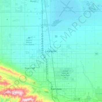
Cliquez sur la carte pour afficher l’altitude.
À propos de cette carte
Nom : Carte topographique Lancaster, altitude, relief.
Lieu : Lancaster, California, 93534, United States (34.53811 -118.29662 34.85811 -117.97662)
Altitude moyenne : 789 m
Altitude minimum : 691 m
Altitude maximum : 1’590 m
According to the United States Census Bureau, the city has a total area of 94.5 square miles (245 km2), of which 94.3 square miles (244 km2) is land and 0.3 square miles (0.78 km2) (0.29%) is water. Lancaster's elevation is 2,350 feet (720 m) above sea level on a high, flat valley surrounded by pristine mountain ranges. Because the elevation is in the range of 2,000 to 3,000 feet (600–900 m) above sea level, the area, like the other parts of the Mojave Desert region, is alternatively referred to as the High Desert. Some cities and communities within the trading area of Lancaster include Palmdale, Rosamond, Lake Los Angeles, Quartz Hill, Ridgecrest, and Santa Clarita. Residents of these desert cities and unincorporated communities share Sierra Highway, Angeles Forest Highway, Angeles Crest Highway (State Route 2), and the Antelope Valley Freeway (State Route 14) for commutes to the San Fernando Valley and Los Angeles Basin.
Autres cartes topographiques
Cliquez sur une carte pour visualiser sa topographie, son altitude et son relief.
Lancaster
United States > California > Lancaster
Lancaster, Los Angeles County, California, United States
Altitude moyenne : 787 m