
Carte topographique Zion Lodge
Carte interactive
Cliquez sur la carte pour afficher l’altitude.
À propos de cette carte
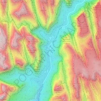
Nom : Carte topographique Zion Lodge, altitude, relief.
Lieu : Zion Lodge, Washington County, Utah, United States (37.22985 -112.97709 37.26985 -112.93709)
Altitude moyenne : 1’722 m
Altitude minimum : 1’263 m
Altitude maximum : 2’176 m
Autres cartes topographiques
Cliquez sur une carte pour visualiser sa topographie, son altitude et son relief.
St. George
United States > Utah > Washington County
St. George, Washington County, Utah, United States
Altitude moyenne : 929 m
Zion National Park
United States > Utah > Washington County
Zion National Park, Washington County, Utah, United States
Altitude moyenne : 1’877 m
Pine Valley
United States > Utah > Washington County
Pine Valley, Washington County, Utah, 84781, United States
Altitude moyenne : 2’092 m
Dammeron Valley
United States > Utah > Washington County
Dammeron Valley, Washington County, Utah, 84783, United States
Altitude moyenne : 1’444 m
Sand Mountain
United States > Utah > Washington County
Sand Mountain, Washington County, Utah, United States
Altitude moyenne : 1’190 m
Toquerville
United States > Utah > Washington County
Toquerville, Washington County, Utah, 84774, United States
Altitude moyenne : 1’301 m
Gunlock
United States > Utah > Washington County
Gunlock, Washington County, Utah, 84733, United States
Altitude moyenne : 1’210 m
Hildale
United States > Utah > Washington County
Hildale, Washington County, Utah, 84784, United States
Altitude moyenne : 1’763 m
Snow Canyon State Park
United States > Utah > Washington County
Snow Canyon State Park, Washington County, Utah, 84738, United States
Altitude moyenne : 1’169 m
Pintura
United States > Utah > Washington County
Pintura, Washington County, Utah, United States
Altitude moyenne : 1’382 m
Silver Reef
United States > Utah > Washington County > Leeds
Silver Reef, Leeds, Washington County, Utah, 84746, United States
Altitude moyenne : 1’185 m
Bee Hive
United States > Utah > Washington County
Bee Hive, Washington County, Utah, 84767, United States
Altitude moyenne : 1’651 m
Kolob Reservoir
United States > Utah > Washington County
Kolob Reservoir, Washington County, Utah, United States
Altitude moyenne : 2’499 m
Washington
United States > Utah > Washington County
Washington, Washington County, Utah, 84780, United States
Altitude moyenne : 924 m
Virgin
United States > Utah > Washington County > Virgin
Virgin, Washington County, Utah, United States
Altitude moyenne : 1’251 m
Mount Baldy
United States > Utah > Washington County
Mount Baldy, Washington County, Utah, United States
Altitude moyenne : 2’352 m
Hurricane Hill
United States > Utah > Washington County > Hurricane
Hurricane Hill, Hurricane, Washington County, Utah, 84745, United States
Altitude moyenne : 1’074 m
New Harmony
United States > Utah > Washington County > New Harmony
New Harmony, Washington County, Utah, United States
Altitude moyenne : 1’636 m
Hurricane
United States > Utah > Washington County
Hurricane, Washington County, Utah, United States
Altitude moyenne : 1’154 m
Pine Valley
United States > Utah > Washington County > Pine Valley
Pine Valley, Washington County, Utah, 84781, United States
Altitude moyenne : 2’075 m
Springdale
United States > Utah > Washington County
Springdale, Washington County, Utah, 84767, United States
Altitude moyenne : 1’349 m
Bloomington Hill
United States > Utah > Washington County > St. George
Bloomington Hill, St. George, Washington County, Utah, 84770-1858, United States
Altitude moyenne : 810 m
Hurricane
United States > Utah > Washington County > Hurricane > Hurricane
Hurricane, Washington County, Utah, 84745, United States
Altitude moyenne : 1’075 m
Central
United States > Utah > Washington County > Central
Central, Washington County, Utah, 84722, United States
Altitude moyenne : 1’636 m
Watchman Trailhead
United States > Utah > Washington County > Springdale
Watchman Trailhead, Springdale, Washington County, Utah, 84767, United States
Altitude moyenne : 1’316 m
Enterprise
United States > Utah > Washington County
Enterprise, Washington County, Utah, 84725, United States
Altitude moyenne : 1’690 m
Ivins
United States > Utah > Washington County
Ivins, Washington County, Utah, 84738, United States
Altitude moyenne : 1’007 m
La Verkin
United States > Utah > Washington County
La Verkin, Washington County, Utah, United States
Altitude moyenne : 1’117 m
Veyo
United States > Utah > Washington County
Veyo, Washington County, Utah, 84782, United States
Altitude moyenne : 1’379 m