
Carte topographique Comté de Longford
Carte interactive
Cliquez sur la carte pour afficher l’altitude.
À propos de cette carte
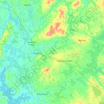
Nom : Carte topographique Comté de Longford, altitude, relief.
Lieu : Comté de Longford, Leinster, Irlande (53.52183 -8.03618 53.94208 -7.37492)
Altitude moyenne : 73 m
Altitude minimum : 33 m
Altitude maximum : 273 m
La plus grande partie du Comté s’étend sur le bassin de la rivière Shannon qui forme sa frontière occidentale avec le Lough Ree. Le paysage est composé de terres peu élevées en altitude (le mont Carn Clonhugh culmine à 279 mètres), de lacs de pâturages et de tourbières.
Autres cartes topographiques
Cliquez sur une carte pour visualiser sa topographie, son altitude et son relief.
Killarney
Killarney, Killarney Municipal District, Comté de Kerry, Munster, Irlande
Altitude moyenne : 57 m
Donegal
Donegal, Cobh Rural ED, Municipal District of Cobh, Comté de Cork, Munster, Irlande
Altitude moyenne : 31 m
Poles
Poles, Moynehall ED, Cavan-Belturbet Municipal District, Comté de Cavan, Ulster, Irlande
Altitude moyenne : 112 m
Galway
Irlande > Comté de Limerick > The Municipal District of Adare — Rathkeale
Galway, Iveruss, The Municipal District of Adare — Rathkeale, Comté de Limerick, Munster, Irlande
Altitude moyenne : 17 m
Douglas
Irlande > Comté de Cork > Cork
Douglas, Cork, Comté de Cork, Munster, Irlande
Altitude moyenne : 34 m
Mayo
Mayo, Cootehill Rural ED, Bailieborough-Cootehill Municipal District, Comté de Cavan, Irlande
Altitude moyenne : 132 m
Garland
Garland, Castletown ED, West Cork, Comté de Cork, Munster, Irlande
Altitude moyenne : 140 m
The Municipal District of Bandon – Kinsale
The Municipal District of Bandon – Kinsale, Comté de Cork, Munster, Irlande
Altitude moyenne : 69 m
The Municipal District of Enniscorthy
The Municipal District of Enniscorthy, Comté de Wexford, Leinster, Irlande
Altitude moyenne : 108 m
Clondalkin LEA
Clondalkin LEA, Clondalkin, South Dublin, Dublin 22, Leinster, Irlande
Altitude moyenne : 124 m
St. George's Parish
St. George's Parish, Inns Quay A ED, Dublin, Dublin 1, Leinster, Irlande
Altitude moyenne : 16 m
The Municipal District of Kells
The Municipal District of Kells, County Meath, Leinster, Irlande
Altitude moyenne : 96 m
Dún Laoghaire
Dún Laoghaire, Dún Laoghaire-Rathdown, County Dublin, Leinster, A96 A258, Irlande
Altitude moyenne : 21 m
Haroldscross West
Haroldscross West, Terenure A ED, Dublin 6W, Dublin, County Dublin, Leinster, D6W F729, Irlande
Altitude moyenne : 33 m
St. Patricksrock
St. Patricksrock, Cashel Rural, The Municipal District of Cahir — Cashel, County Tipperary, Munster, Irlande
Altitude moyenne : 101 m
Lough Derg
Lough Derg, L4044, Kilcooney, Drummaan, Killaloe Municipal District, County Clare, Munster, Irlande
Altitude moyenne : 87 m
Lough Corrib
Lough Corrib, Carrowmoreknock Pier, Carrowmoreknock, Wormhole ED, Conamara Municipal District, County Galway, Connacht, Irlande
Altitude moyenne : 46 m
Ballycroy National Park
Ballycroy National Park, Scardaun, Ballycroy South ED, Westport-Belmullet Municipal District, County Mayo, Connacht, Irlande
Altitude moyenne : 152 m
Lough Mask
Lough Mask, R300, Cappaghduff East, Cappaghduff ED, Castlebar Municipal District, County Mayo, Connacht, Irlande
Altitude moyenne : 68 m
Cherry Orchard
Cherry Orchard, Merchants Quay E ED, Dublin 8, Dublin, County Dublin, Leinster, Irlande
Altitude moyenne : 25 m
Cathair na Gaillimhe
Irlande > Cathair na Gaillimhe
Galway, Cathair na Gaillimhe, County Galway, Connacht, H91 YD86, Irlande
Altitude moyenne : 26 m
île d'Achill
île d'Achill, Westport-Belmullet Municipal District, County Mayo, Connacht, Irlande
Altitude moyenne : 42 m
Parc national du Connemara
Parc national du Connemara, Bog Bridge, Addergoole, Ballynakill ED, Conamara Municipal District, County Galway, Connacht, Irlande
Altitude moyenne : 211 m