
Carte topographique West Midlands
Carte interactive
Cliquez sur la carte pour afficher l’altitude.
À propos de cette carte
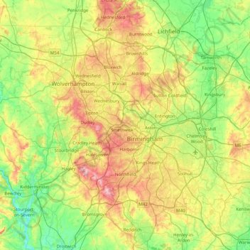
Nom : Carte topographique West Midlands, altitude, relief.
Altitude moyenne : 113 m
Altitude minimum : 15 m
Altitude maximum : 307 m
Autres cartes topographiques
Cliquez sur une carte pour visualiser sa topographie, son altitude et son relief.
Edstone
United Kingdom > England > Warwickshire > Stratford-on-Avon > Wootton Wawen CP
Altitude moyenne : 90 m
Ascott
United Kingdom > England > Warwickshire > Stratford-on-Avon > Whichford
Altitude moyenne : 160 m
Brook End
United Kingdom > England > Warwickshire > North Warwickshire > Hurley
Altitude moyenne : 107 m
Vale View
United Kingdom > England > Warwickshire > Nuneaton and Bedworth > Nuneaton
Altitude moyenne : 113 m
Walton
United Kingdom > England > Warwickshire > Stratford-on-Avon > Wellesbourne
Altitude moyenne : 76 m
Rowington Green
United Kingdom > England > Warwickshire > Warwick > Rowington
Altitude moyenne : 114 m
Brinklow Marina
United Kingdom > England > Warwickshire > Rugby > King's Newnham CP
Altitude moyenne : 95 m
Sutton-under-Brailes
United Kingdom > England > Warwickshire > Stratford-on-Avon > Stourton
Altitude moyenne : 125 m
Edgehill
United Kingdom > England > Warwickshire > Stratford-on-Avon > Radway
Altitude moyenne : 157 m
Nuneaton Common
United Kingdom > England > Warwickshire > Nuneaton and Bedworth
Altitude moyenne : 127 m
Church End
United Kingdom > England > Warwickshire > North Warwickshire > Ansley CP
Altitude moyenne : 151 m
Oversley Wood
United Kingdom > England > Warwickshire > Stratford-on-Avon > Alcester > Exhall
Altitude moyenne : 64 m
Merevale Lake
United Kingdom > England > Warwickshire > North Warwickshire > Atherstone
Altitude moyenne : 119 m
Curdworth Locks
United Kingdom > England > Warwickshire > North Warwickshire > Kingsbury > Curdworth CP
Altitude moyenne : 80 m
Burton Dassett Hills Country Park
United Kingdom > England > Warwickshire > Stratford-on-Avon > Northend > Burton Dassett CP
Altitude moyenne : 132 m
Cranhill
United Kingdom > England > Warwickshire > Stratford-on-Avon > Ardens Grafton
Altitude moyenne : 57 m
Hartshill Hayes Country Park
United Kingdom > England > Warwickshire > North Warwickshire > Ansley Common
Altitude moyenne : 127 m
Lye Green
United Kingdom > England > Warwickshire > Stratford-on-Avon > Claverdon > Lye Green
Altitude moyenne : 106 m
Winderton
United Kingdom > England > Warwickshire > Stratford-on-Avon > Winderton
Altitude moyenne : 151 m
Upper Quinton
United Kingdom > England > Warwickshire > Stratford-on-Avon > Lower Quinton > Upper Quinton
Altitude moyenne : 70 m
Hampton on the Hill
United Kingdom > England > Warwickshire > Warwick > Hampton on the Hill
Altitude moyenne : 75 m
Bishop's Itchington
United Kingdom > England > Warwickshire > Stratford-on-Avon
Altitude moyenne : 105 m
Ladbroke (Millennium Green)
United Kingdom > England > Warwickshire > Stratford-on-Avon > Ladbroke CP
Altitude moyenne : 98 m
Pillerton Hersey
United Kingdom > England > Warwickshire > Stratford-on-Avon > Pillerton Hersey
Altitude moyenne : 92 m
Lower Tysoe
United Kingdom > England > Warwickshire > Stratford-on-Avon > Middle Tysoe
Altitude moyenne : 127 m
Tredington
United Kingdom > England > Warwickshire > Stratford-on-Avon > Tredington
Altitude moyenne : 73 m
Pathlow
United Kingdom > England > Warwickshire > Stratford-on-Avon > Wilmcote CP
Altitude moyenne : 84 m
Napton on the Hill
United Kingdom > England > Warwickshire > Stratford-on-Avon
Altitude moyenne : 113 m
Lower Binton
United Kingdom > England > Warwickshire > Stratford-on-Avon > Binton
Altitude moyenne : 52 m
Pooley Country Park
United Kingdom > England > Warwickshire > North Warwickshire > Polesworth
Altitude moyenne : 76 m
Lea Marston Purification Lakes
United Kingdom > England > Warwickshire > North Warwickshire > Marston
Altitude moyenne : 70 m
Horeston Grange
United Kingdom > England > Warwickshire > Nuneaton and Bedworth
Altitude moyenne : 90 m