
Faire un don
Équipez-vous pour votre prochaine aventure :
En tant que Partenaire Amazon, ce site perçoit une commission sur les achats éligibles sans surcoût pour vous.
Carte topographique Berks County
Cliquez sur la carte pour afficher l’altitude.
Équipez-vous pour votre prochaine aventure :
En tant que Partenaire Amazon, ce site perçoit une commission sur les achats éligibles sans surcoût pour vous.
À propos de cette carte
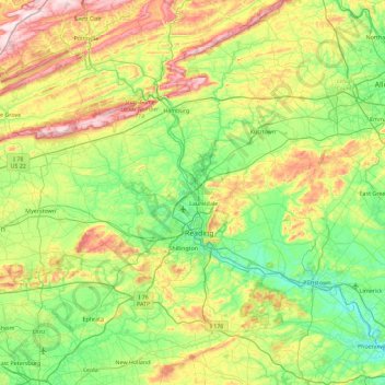
Nom : Carte topographique Berks County, altitude, relief.
Lieu : Berks County, Pennsylvania, United States (40.13715 -76.44018 40.67718 -75.52969)
Altitude moyenne : 181 m
Altitude minimum : 26 m
Altitude maximum : 532 m
Faire un don
Équipez-vous pour votre prochaine aventure :
En tant que Partenaire Amazon, ce site perçoit une commission sur les achats éligibles sans surcoût pour vous.
Autres cartes topographiques
Cliquez sur une carte pour visualiser sa topographie, son altitude et son relief.
Croydon Heights
United States > Pennsylvania > Bucks County > Bristol Township > Croydon
Altitude moyenne : 10 m
East Texas
United States > Pennsylvania > Lehigh County > Lower Macungie Township
Altitude moyenne : 126 m
Carlisle Springs
United States > Pennsylvania > Cumberland County > Middlesex Township
Altitude moyenne : 182 m
Faire un don
Équipez-vous pour votre prochaine aventure :
En tant que Partenaire Amazon, ce site perçoit une commission sur les achats éligibles sans surcoût pour vous.
Fitzwatertown
United States > Pennsylvania > Montgomery County > Upper Dublin Township
Altitude moyenne : 86 m
Exton
United States > Pennsylvania > Chester County > West Whiteland Township
Altitude moyenne : 125 m
Illick's Mill Road Gateway
United States > Pennsylvania > Northampton County > Bethlehem
Altitude moyenne : 105 m
Faire un don
Équipez-vous pour votre prochaine aventure :
En tant que Partenaire Amazon, ce site perçoit une commission sur les achats éligibles sans surcoût pour vous.
Spring Plains
United States > Pennsylvania > York County > Springettsbury Township
Altitude moyenne : 151 m
Faire un don
Équipez-vous pour votre prochaine aventure :
En tant que Partenaire Amazon, ce site perçoit une commission sur les achats éligibles sans surcoût pour vous.
Knickerbocker
United States > Pennsylvania > Chester County > Willistown Township
Altitude moyenne : 127 m
Dingmans Ferry
United States > Pennsylvania > Pike County > Delaware Township
Altitude moyenne : 192 m
Donegal Lake
United States > Pennsylvania > Westmoreland County > Donegal Township
Altitude moyenne : 493 m
Faire un don
Équipez-vous pour votre prochaine aventure :
En tant que Partenaire Amazon, ce site perçoit une commission sur les achats éligibles sans surcoût pour vous.
Bass Lake
United States > Pennsylvania > York County > Newberry Township > Valley Green
Altitude moyenne : 143 m
Centreville
United States > Pennsylvania > Lehigh County > Lower Macungie Township
Altitude moyenne : 144 m
Sturgeon
United States > Pennsylvania > Allegheny County > North Fayette Township
Altitude moyenne : 334 m
Glade Mills
United States > Pennsylvania > Butler County > Middlesex Township
Altitude moyenne : 359 m
Faire un don
Équipez-vous pour votre prochaine aventure :
En tant que Partenaire Amazon, ce site perçoit une commission sur les achats éligibles sans surcoût pour vous.
Bentley Creek
United States > Pennsylvania > Bradford County > Ridgebury Township
Altitude moyenne : 417 m
Freemont
United States > Pennsylvania > Chester County > West Nottingham Township
Altitude moyenne : 115 m
Faire un don
Équipez-vous pour votre prochaine aventure :
En tant que Partenaire Amazon, ce site perçoit une commission sur les achats éligibles sans surcoût pour vous.
Franklin Pike Corners
United States > Pennsylvania > Crawford County > West Mead Township
Altitude moyenne : 377 m
Woxall
United States > Pennsylvania > Montgomery County > Upper Salford Township
Altitude moyenne : 98 m
Hamilton Court
United States > Pennsylvania > Montgomery County > Lower Merion Township > Ardmore
Altitude moyenne : 102 m
Faire un don
Équipez-vous pour votre prochaine aventure :
En tant que Partenaire Amazon, ce site perçoit une commission sur les achats éligibles sans surcoût pour vous.
Kellettville
United States > Pennsylvania > Forest County > Kingsley Township
Altitude moyenne : 441 m
Perryville
United States > Pennsylvania > Westmoreland County > Bell Township
Altitude moyenne : 365 m
Faire un don
Équipez-vous pour votre prochaine aventure :
En tant que Partenaire Amazon, ce site perçoit une commission sur les achats éligibles sans surcoût pour vous.
Middlebury Center
United States > Pennsylvania > Tioga County > Middlebury Township
Altitude moyenne : 462 m
Faire un don
Équipez-vous pour votre prochaine aventure :
En tant que Partenaire Amazon, ce site perçoit une commission sur les achats éligibles sans surcoût pour vous.
Canoe Creek
United States > Pennsylvania > Blair County > Frankstown Township
Altitude moyenne : 347 m
Arlingham
United States > Pennsylvania > Montgomery County > Springfield Township
Altitude moyenne : 66 m
Faire un don
Équipez-vous pour votre prochaine aventure :
En tant que Partenaire Amazon, ce site perçoit une commission sur les achats éligibles sans surcoût pour vous.
Faire un don
Équipez-vous pour votre prochaine aventure :
En tant que Partenaire Amazon, ce site perçoit une commission sur les achats éligibles sans surcoût pour vous.
Dalmatia
United States > Pennsylvania > Northumberland County > Lower Mahanoy Township
Altitude moyenne : 172 m
Stoverstown
United States > Pennsylvania > York County > North Codorus Township
Altitude moyenne : 171 m
Springtown
United States > Pennsylvania > Bucks County > Springfield Township
Altitude moyenne : 163 m
Faire un don
Équipez-vous pour votre prochaine aventure :
En tant que Partenaire Amazon, ce site perçoit une commission sur les achats éligibles sans surcoût pour vous.
Blue Mountain
United States > Pennsylvania > Schuylkill County > Washington Township
The ridge of Blue Mountain runs for 150 miles (240 km) through Pennsylvania, reaching an elevation of 2,270 feet (690 m) above sea level just north of the Pennsylvania Turnpike, near the borough of Newburg. Most of the ridgecrest, however, only reaches between 1,400 and 1,700 feet (430 and 520 m) in elevation.…
Altitude moyenne : 226 m
Faire un don
Équipez-vous pour votre prochaine aventure :
En tant que Partenaire Amazon, ce site perçoit une commission sur les achats éligibles sans surcoût pour vous.
Hazelton Mills
United States > Pennsylvania > McKean County > Bradford Township
Altitude moyenne : 598 m
Faire un don
Équipez-vous pour votre prochaine aventure :
En tant que Partenaire Amazon, ce site perçoit une commission sur les achats éligibles sans surcoût pour vous.
East Waterford
United States > Pennsylvania > Juniata County > Tuscarora Township
Altitude moyenne : 257 m
Bartram's Garden
United States > Pennsylvania > Philadelphia County > Philadelphia
Altitude moyenne : 13 m
Mauntain View Lake
United States > Pennsylvania > Dauphin County > Halifax Township
Altitude moyenne : 207 m
Faire un don
Équipez-vous pour votre prochaine aventure :
En tant que Partenaire Amazon, ce site perçoit une commission sur les achats éligibles sans surcoût pour vous.
Long Pond
United States > Pennsylvania > Monroe County > Tunkhannock Township
Long Pond is named after the wetland topography formed by Tunkhannock Creek. Within the Long Pond community are public access lands, containing many species of plants and animals. Long Pond has been called "the most unique inland freshwater wetland in the state".
Altitude moyenne : 571 m
Tyler State Park
United States > Pennsylvania > Bucks County > Northampton Township
Altitude moyenne : 67 m
Faire un don
Équipez-vous pour votre prochaine aventure :
En tant que Partenaire Amazon, ce site perçoit une commission sur les achats éligibles sans surcoût pour vous.
Intercourse
United States > Pennsylvania > Lancaster County > Leacock Township
Altitude moyenne : 127 m
Faire un don
Équipez-vous pour votre prochaine aventure :
En tant que Partenaire Amazon, ce site perçoit une commission sur les achats éligibles sans surcoût pour vous.
Holiday Poconos
United States > Pennsylvania > Carbon County > Kidder Township
Altitude moyenne : 519 m
Strickhousers
United States > Pennsylvania > York County > North Codorus Township
Altitude moyenne : 205 m
Faire un don
Équipez-vous pour votre prochaine aventure :
En tant que Partenaire Amazon, ce site perçoit une commission sur les achats éligibles sans surcoût pour vous.
Central Highlands
United States > Pennsylvania > Allegheny County > Elizabeth Township
Altitude moyenne : 327 m
Faire un don
Équipez-vous pour votre prochaine aventure :
En tant que Partenaire Amazon, ce site perçoit une commission sur les achats éligibles sans surcoût pour vous.
Pocono Lake
United States > Pennsylvania > Monroe County > Tobyhanna Township
Altitude moyenne : 543 m
Rydal Park
United States > Pennsylvania > Montgomery County > Abington Township
Altitude moyenne : 87 m
Plumsteadville
United States > Pennsylvania > Bucks County > Plumstead Township
Altitude moyenne : 160 m
Canoe Creek
United States > Pennsylvania > Blair County > Frankstown Township
Altitude moyenne : 347 m
Faire un don
Équipez-vous pour votre prochaine aventure :
En tant que Partenaire Amazon, ce site perçoit une commission sur les achats éligibles sans surcoût pour vous.
Loyalsockville
United States > Pennsylvania > Lycoming County > Upper Fairfield Township
Altitude moyenne : 262 m
McGovernsville
United States > Pennsylvania > Lancaster County > East Hempfield Township > Rohrerstown
Altitude moyenne : 109 m
Faire un don
Équipez-vous pour votre prochaine aventure :
En tant que Partenaire Amazon, ce site perçoit une commission sur les achats éligibles sans surcoût pour vous.
Loch Lomond Junction
United States > Pennsylvania > Centre County > Rush Township
Altitude moyenne : 460 m
Farmdale
United States > Pennsylvania > Lancaster County > West Hempfield Township
Altitude moyenne : 131 m
Faire un don
Équipez-vous pour votre prochaine aventure :
En tant que Partenaire Amazon, ce site perçoit une commission sur les achats éligibles sans surcoût pour vous.
Valley Forge
United States > Pennsylvania > Chester County > Schuylkill Township
Altitude moyenne : 78 m
Faire un don
Équipez-vous pour votre prochaine aventure :
En tant que Partenaire Amazon, ce site perçoit une commission sur les achats éligibles sans surcoût pour vous.
East Springfield
United States > Pennsylvania > Erie County > Springfield Township
Altitude moyenne : 229 m
Gwynedd Valley
United States > Pennsylvania > Montgomery County > Lower Gwynedd Township
Altitude moyenne : 93 m
Schollard
United States > Pennsylvania > Mercer County > Springfield Township > Leesburg
Altitude moyenne : 379 m
Faire un don
Équipez-vous pour votre prochaine aventure :
En tant que Partenaire Amazon, ce site perçoit une commission sur les achats éligibles sans surcoût pour vous.
Teepleville
United States > Pennsylvania > Crawford County > Richmond Township
Altitude moyenne : 386 m
Raven Rock Mountain
United States > Pennsylvania > Adams County > Liberty Township
Altitude moyenne : 312 m
Faire un don
Équipez-vous pour votre prochaine aventure :
En tant que Partenaire Amazon, ce site perçoit une commission sur les achats éligibles sans surcoût pour vous.