
Carte topographique Alamance County
Carte interactive
Cliquez sur la carte pour afficher l’altitude.
À propos de cette carte
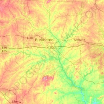
Nom : Carte topographique Alamance County, altitude, relief.
Lieu : Alamance County, North Carolina, United States (35.84331 -79.54243 36.25002 -79.23660)
Altitude moyenne : 194 m
Altitude minimum : 115 m
Altitude maximum : 294 m
Autres cartes topographiques
Cliquez sur une carte pour visualiser sa topographie, son altitude et son relief.
Highlands
United States > North Carolina > Macon County > Highlands
Highlands was founded in 1875 after its two founders, Samuel Truman Kelsey and Clinton Carter Hutchinson, drew lines from Chicago to Savannah and from New Orleans to New York City. They felt that the place where these lines met would eventually become a great trading center and commercial crossroads. Highlands…
Altitude moyenne : 1’090 m
Long Leaf Acres
United States > North Carolina > New Hanover County > Wilmington
Altitude moyenne : 11 m
Ballantyne's Backyard
United States > North Carolina > Mecklenburg County > Charlotte
Altitude moyenne : 183 m
Appalachian Mountains
United States > North Carolina > Yancey County
The Appalachian Mountains (French: Appalaches), often called the Appalachians, are a system of mountains in eastern to northeastern North America. The Appalachians first formed roughly 480 million years ago during the Ordovician Period. They once reached elevations similar to those of the Alps and the Rocky…
Altitude moyenne : 1’463 m
Boiling Spring Lake Dam
United States > North Carolina > Brunswick County > Boiling Spring Lakes
Altitude moyenne : 14 m
Country Club Estates
United States > North Carolina > Alamance County > Burlington
Altitude moyenne : 195 m
Loch Lommond
United States > North Carolina > Cumberland County > Fayetteville
Altitude moyenne : 70 m
Maplewood
United States > North Carolina > Richmond County > Rockingham > East Rockingham
Altitude moyenne : 83 m
Mount Mitchell
United States > North Carolina > Yancey County
Mount Mitchell (Attakulla in Cherokee) is the highest peak of the Appalachian Mountains and the highest peak in mainland North America east of the Mississippi River. It is located near Burnsville in Yancey County, North Carolina in the Black Mountain subrange of the Appalachians about 19 miles (31 km)…
Altitude moyenne : 1’743 m
Mount Mitchell
United States > North Carolina > Yancey County
Mount Mitchell, known in Cherokee as Attakulla, is the highest peak of the Appalachian Mountains and the highest peak in mainland eastern North America. It is located near Burnsville in Yancey County, North Carolina in the Black Mountain subrange of the Appalachians about 19 miles (31 km) northeast of…
Altitude moyenne : 1’743 m
Appalachian Ski Mountain Dam
United States > North Carolina > Watauga County
Altitude moyenne : 1’113 m
Reynolda Village
United States > North Carolina > Forsyth County > Winston-Salem
Altitude moyenne : 278 m
Tuckaseegee Park
United States > North Carolina > Mecklenburg County > Charlotte
Altitude moyenne : 233 m
Oak Ridge Park
United States > North Carolina > Richmond County > East Rockingham
Altitude moyenne : 85 m
Bald Head Island
United States > North Carolina > Brunswick County > Bald Head Island
Altitude moyenne : 3 m
Appalachian Mountains
United States > North Carolina > Yancey County
The range is older than the other major mountain range in North America, the Rocky Mountains of the west. Some of the outcrops in the Appalachians contain rocks formed during the Precambrian era. The geologic processes that led to the formation of the Appalachian Mountains started 1.1 billion years ago. The…
Altitude moyenne : 1’463 m