
Carte topographique South Downs National Park
Carte interactive
Cliquez sur la carte pour afficher l’altitude.
South Downs National Park
The South Downs National Park's chalk downland is a feature that sets it apart from other national parks in Britain. However, almost a quarter (23%) of the national park consists of a quite different and strongly contrasting physiographic region, the western Weald, whose densely wooded hills and vales are based on an older Wealden geology of resistant sandstones and softer clays. The highest point in the national park, Blackdown, at 280 m (919 ft) above sea level, is in fact situated in the Weald, on the Greensand Ridge, whereas the highest point on the chalk escarpment of the South Downs, Butser Hill, has an elevation of 271 m (889 ft) above sea level.
À propos de cette carte
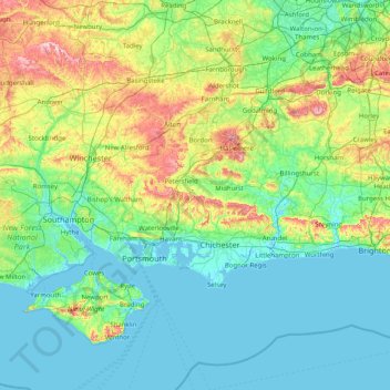
Nom : Carte topographique South Downs National Park, altitude, relief.
Lieu : South Downs National Park, West Sussex, England, United Kingdom (50.73324 -1.33670 51.19343 0.27259)
Altitude moyenne : 54 m
Altitude minimum : -3 m
Altitude maximum : 297 m
Autres cartes topographiques
Cliquez sur une carte pour visualiser sa topographie, son altitude et son relief.
Blackdown
United Kingdom > England > West Sussex > Chichester
Blackdown, or Black Down, summit elevation 279.7 metres (918 ft) AMSL, is the highest point in both the historic county of Sussex and the South Downs National Park. It is one of the highest points in the south east of England, exceeded by Walbury Hill, Leith Hill and Pilot Hill. Blackdown is protected as part…
Altitude moyenne : 165 m
Washington Common
United Kingdom > England > West Sussex > Storrington > Washington
Altitude moyenne : 61 m
Worth Abbey
United Kingdom > England > West Sussex > Mid Sussex > Turners Hill
Altitude moyenne : 124 m
Gay Street
United Kingdom > England > West Sussex > Horsham > West Chiltington
Altitude moyenne : 38 m
Sullington Warren
United Kingdom > England > West Sussex > Horsham > Storrington
Altitude moyenne : 54 m
Henry Burt Wood
United Kingdom > England > West Sussex > Mid Sussex > Burgess Hill
Altitude moyenne : 39 m
Smock Alley
United Kingdom > England > West Sussex > Horsham > West Chiltington Common
Altitude moyenne : 38 m
Ardingly Reservoir
United Kingdom > England > West Sussex > Mid Sussex > Ardingly
Altitude moyenne : 98 m
Blackdown
United Kingdom > England > West Sussex > Chichester
Blackdown, or Black Down, summit elevation 279.7 metres (918 ft) AMSL, is the highest point in both the historic county of Sussex and the South Downs National Park. It is one of the highest points in the south east of England, exceeded by Walbury Hill, Leith Hill and Pilot Hill. Blackdown is protected as part…
Altitude moyenne : 165 m
Horncroft Common Plantation
United Kingdom > England > West Sussex > Chichester
Altitude moyenne : 22 m
Westerton
United Kingdom > England > West Sussex > Chichester > Westhampnett > Westerton
Altitude moyenne : 30 m
Batchelors Farm Nature Conservation Site
United Kingdom > England > West Sussex > Mid Sussex District > Burgess Hill
Altitude moyenne : 49 m
Gossops Green
United Kingdom > England > West Sussex > Crawley > Gossops Green
Altitude moyenne : 80 m
Brook Street
United Kingdom > England > West Sussex > Mid Sussex > Whitemans Green
Altitude moyenne : 76 m