
Carte topographique Bradenton
Carte interactive
Cliquez sur la carte pour afficher l’altitude.
À propos de cette carte
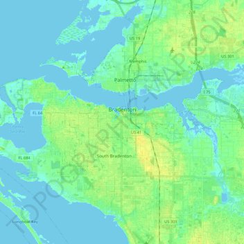
Nom : Carte topographique Bradenton, altitude, relief.
Lieu : Bradenton, Manatee County, Florida, United States (27.45516 -82.69069 27.52296 -82.47943)
Altitude moyenne : 5 m
Altitude minimum : -5 m
Altitude maximum : 17 m
Bradenton would be affected by World War II like many other cities in Florida and the United States. During the war, Manatee County would have its own Civil Defense battalion in it with two subunits existing in Bradenton and another for nearby Manatee. A recreational center would be opened in March 1942 at a building on the intersection of 6th Avenue and 12th Street West in the downtown area to be used by soldiers. The recreation center would close in November 1945 and would be popular with local soldiers and visited even by those who were stationed outside of Bradenton. The Bradenton Police Chief, Clyde Benton would expand the police force by naming 45 officers to serve without pay during the war. Camp Weatherford located at LECOM Field would exist for 8 months at some point during the war as a training center for the US Army Signal Corps. About 350 soldiers would be trained there during its existence. The camp itself often had an issue with being flooded because of the rainy climate, showers at the camp occurring often, clothes being washed, its low elevation and is located nearby to Wares Creek. A soldier named Joe Grossman at the camp would run a radio show broadcasting on WSPB called Weatherford Shinings. Local residents would accommodate the troops stationed at the base in a variety of ways. Bradenton would merge with nearby Manatee (incorporated in 1888) in 1943. Manatee would face similar financial problems as Bradenton did in regards to their bonds and faced high debt levels as a result but Manatee could not pay off the bonds.
Autres cartes topographiques
Cliquez sur une carte pour visualiser sa topographie, son altitude et son relief.
Anna Maria island
United States > Florida > Manatee County
Anna Maria island, Manatee County, Florida, 34216, United States
Altitude moyenne : 2 m
Parrish
United States > Florida > Manatee County
Parrish, Manatee County, Florida, 34219, United States
Altitude moyenne : 12 m
Longboat Key
United States > Florida > Manatee County
Longboat Key, Manatee County, Florida, 34228, United States
Altitude moyenne : 1 m
Bradenton
United States > Florida > Manatee County > Bradenton
Bradenton, Manatee County, Florida, 34205, United States
Altitude moyenne : 5 m
Tom Bennett Park
United States > Florida > Manatee County
Tom Bennett Park, Manatee County, Florida, United States
Altitude moyenne : 4 m
Palmetto
United States > Florida > Manatee County
Palmetto, Manatee County, Florida, United States
Altitude moyenne : 4 m
South Bradenton
United States > Florida > Manatee County > South Bradenton
South Bradenton, Cedar Hammock, South Bradenton, Manatee County, Florida, United States
Altitude moyenne : 10 m
Myakka City
United States > Florida > Manatee County
Myakka City, Manatee County, Florida, United States
Altitude moyenne : 14 m
Ellenton
United States > Florida > Manatee County
Ellenton, Manatee County, Florida, United States
Altitude moyenne : 4 m
Anna Maria Bayfront Park
United States > Florida > Manatee County > Anna Maria island
Anna Maria Bayfront Park, Anna Maria island, Manatee County, Florida, United States
Altitude moyenne : 1 m
Duette
United States > Florida > Manatee County
Duette, Manatee County, Florida, United States
Altitude moyenne : 38 m
Manatee
United States > Florida > Manatee County > Bradenton
Manatee, Bradenton, Manatee County, Florida, 34208, United States
Altitude moyenne : 4 m
Palma Sola Bay
United States > Florida > Manatee County > Bradenton
Palma Sola Bay, Bradenton, Manatee County, Florida, United States
Altitude moyenne : 2 m
Bradenton Beach
United States > Florida > Manatee County
Bradenton Beach, Manatee County, Florida, 34215, United States
Altitude moyenne : 1 m
Terra Ceia
United States > Florida > Manatee County
Terra Ceia, Manatee County, Florida, 34250, United States
Altitude moyenne : 2 m
Cortez
United States > Florida > Manatee County
Cortez, Manatee County, Florida, 34215, United States
Altitude moyenne : 2 m
Ellenton
United States > Florida > Manatee County > Ellenton
Ellenton, Manatee County, Florida, United States
Altitude moyenne : 5 m
West Bradenton
United States > Florida > Manatee County > West Bradenton
West Bradenton, Manatee County, Florida, United States
Altitude moyenne : 6 m
Braden River
United States > Florida > Manatee County
Braden River, Manatee County, Florida, 34202, United States
Altitude moyenne : 10 m
Rye
United States > Florida > Manatee County > Rye
Rye, Manatee County, Florida, 34212, United States
Altitude moyenne : 10 m
Palma Sola
United States > Florida > Manatee County
Palma Sola, Manatee County, Florida, 34209, United States
Altitude moyenne : 4 m
Brandenton Beach
United States > Florida > Manatee County
Brandenton Beach, Manatee County, Florida, United States
Altitude moyenne : 1 m
Bayshore Gardens
United States > Florida > Manatee County
Bayshore Gardens, Manatee County, Florida, 34207, United States
Altitude moyenne : 8 m
Whitfield
United States > Florida > Manatee County
Whitfield, Manatee County, Florida, United States
Altitude moyenne : 6 m
Holmes Beach
United States > Florida > Manatee County
Holmes Beach, Manatee County, Florida, United States
Altitude moyenne : 1 m
Longbeach
United States > Florida > Manatee County > Longboat Key > Longbeach
Longbeach, Longboat Key, Manatee County, Florida, 34215, United States
Altitude moyenne : 1 m