
Carte topographique Magog
Carte interactive
Cliquez sur la carte pour afficher l’altitude.
À propos de cette carte
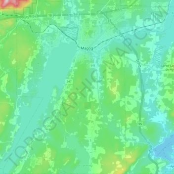
Nom : Carte topographique Magog, altitude, relief.
Lieu : Magog, Memphrémagog, Estrie, Quebec, Canada (45.16080 -72.24729 45.30571 -72.04219)
Altitude moyenne : 250 m
Altitude minimum : 159 m
Altitude maximum : 674 m
Autres cartes topographiques
Cliquez sur une carte pour visualiser sa topographie, son altitude et son relief.
Ayer's Cliff
Canada > Quebec > Memphrémagog
Ayer's Cliff, Memphrémagog, Estrie, Quebec, Canada
Altitude moyenne : 172 m
Mont Boisjoli
Canada > Quebec > Memphrémagog > Hatley (Canton)
Mont Boisjoli, Hatley (Canton), Memphrémagog, Estrie, Quebec, J0B 2C0, Canada
Altitude moyenne : 267 m
Province Island
Canada > Quebec > Memphrémagog > Ogden > Cedarville
Province Island, Cedarville, Ogden, Memphrémagog, Estrie, Quebec, Canada
Altitude moyenne : 205 m
Stanstead (Ville)
Canada > Quebec > Memphrémagog
Stanstead (Ville), Memphrémagog, Estrie, Quebec, Canada
Altitude moyenne : 325 m
Georgeville
Canada > Quebec > Memphrémagog > Stanstead (Canton)
Georgeville, Stanstead (Canton), Memphrémagog, Estrie, Quebec, J0B 1T0, Canada
Altitude moyenne : 237 m
Saint-Étienne-de-Bolton
Canada > Quebec > Memphrémagog
Saint-Étienne-de-Bolton, Memphrémagog, Estrie, Quebec, Canada
Altitude moyenne : 338 m
Sainte-Catherine-de-Hatley
Canada > Quebec > Memphrémagog
Sainte-Catherine-de-Hatley, Memphrémagog, Estrie, Quebec, J0B 1W0, Canada
Altitude moyenne : 244 m
Orford
Canada > Quebec > Memphrémagog
Orford, Memphrémagog, Estrie, Quebec, Canada
Altitude moyenne : 319 m
Vale Perkins
Canada > Quebec > Memphrémagog > Potton
Vale Perkins, Potton, Memphrémagog, Estrie, Quebec, Canada
Altitude moyenne : 287 m
Parc national du Mont-Orford
Canada > Quebec > Memphrémagog > Orford
Parc national du Mont-Orford, Orford, Memphrémagog, Estrie, Quebec, Canada
Altitude moyenne : 336 m
Ayers Cliff Exposition Grounds
Canada > Quebec > Memphrémagog > Ayer's Cliff
Ayers Cliff Exposition Grounds, Ayer's Cliff, Memphrémagog, Estrie, Quebec, Canada
Altitude moyenne : 174 m
Mansonville
Canada > Quebec > Memphrémagog > Potton
Mansonville, Potton, Memphrémagog, Estrie, Quebec, J0E 1X0, Canada
Altitude moyenne : 211 m
Bolton-Est
Canada > Quebec > Memphrémagog
Bolton-Est, Memphrémagog, Estrie, Quebec, J0E 1G0, Canada
Altitude moyenne : 331 m
Potton
Canada > Quebec > Memphrémagog
Potton, Memphrémagog, Estrie, Quebec, J0E 1X0, Canada
Altitude moyenne : 321 m
Eastman
Canada > Quebec > Memphrémagog
Eastman, Memphrémagog, Estrie, Quebec, J0E 1P0, Canada
Altitude moyenne : 314 m
North Hatley
Canada > Quebec > Memphrémagog
North Hatley, Memphrémagog, Estrie, Quebec, Canada
Altitude moyenne : 212 m
Stukely-Sud
Canada > Quebec > Memphrémagog
Stukely-Sud, Memphrémagog, Estrie, Quebec, J0E 2J0, Canada
Altitude moyenne : 281 m
Hatley
Canada > Quebec > Memphrémagog
Hatley, Memphrémagog, Estrie, Quebec, Canada
Altitude moyenne : 294 m
Austin
Canada > Quebec > Memphrémagog
Austin, Memphrémagog, Estrie, Quebec, J0B 1B0, Canada
Altitude moyenne : 290 m