
Carte topographique Poulton-le-Fylde
Carte interactive
Cliquez sur la carte pour afficher l’altitude.
À propos de cette carte
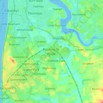
Nom : Carte topographique Poulton-le-Fylde, altitude, relief.
Altitude moyenne : 12 m
Altitude minimum : -2 m
Altitude maximum : 43 m
Autres cartes topographiques
Cliquez sur une carte pour visualiser sa topographie, son altitude et son relief.
Hardhorn
United Kingdom > England > Lancashire > Borough of Wyre
Hardhorn, Borough of Wyre, Lancashire, England, FY6 8DN, United Kingdom
Altitude moyenne : 13 m
Little Thornton
United Kingdom > England > Lancashire > Borough of Wyre
Little Thornton, Borough of Wyre, Lancashire, England, FY5 5LU, United Kingdom
Altitude moyenne : 8 m
Parlick
United Kingdom > England > Lancashire > Borough of Wyre
Parlick, Borough of Wyre, Lancashire, England, PR3 2NZ, United Kingdom
Altitude moyenne : 251 m
River Brock
United Kingdom > England > Lancashire > Borough of Wyre
River Brock, Borough of Wyre, Lancashire, England, United Kingdom
Altitude moyenne : 111 m
St Michael's on Wyre
United Kingdom > England > Lancashire > Borough of Wyre
St Michael's on Wyre, Borough of Wyre, Lancashire, England, PR3 0TE, United Kingdom
Altitude moyenne : 10 m
Out Rawcliffe
United Kingdom > England > Lancashire > Borough of Wyre
Out Rawcliffe, Borough of Wyre, Lancashire, England, United Kingdom
Altitude moyenne : 10 m
Myerscough
United Kingdom > England > Lancashire > Borough of Wyre
Myerscough, Myerscough and Bilsborrow, Borough of Wyre, Lancashire, England, PR3 0RS, United Kingdom
Altitude moyenne : 17 m
Fleetwood
United Kingdom > England > Lancashire > Borough of Wyre
Fleetwood, Borough of Wyre, Lancashire, England, United Kingdom
Altitude moyenne : 2 m
Fair Snape Fell
United Kingdom > England > Lancashire > Borough of Wyre
Fair Snape Fell, Borough of Wyre, Lancashire, England, PR3 2NZ, United Kingdom
Altitude moyenne : 406 m
Garstang
United Kingdom > England > Lancashire > Borough of Wyre
Garstang, Borough of Wyre, Lancashire, England, United Kingdom
Altitude moyenne : 24 m
Great Eccleston
United Kingdom > England > Lancashire > Borough of Wyre
Great Eccleston, Borough of Wyre, Lancashire, England, United Kingdom
Altitude moyenne : 12 m
Bilsborrow
United Kingdom > England > Lancashire > Borough of Wyre
Bilsborrow, Myerscough and Bilsborrow, Borough of Wyre, Lancashire, England, PR3 0QR, United Kingdom
Altitude moyenne : 28 m
Preesall
United Kingdom > England > Lancashire > Borough of Wyre
Preesall, Borough of Wyre, Lancashire, England, United Kingdom
Altitude moyenne : 3 m
Hambleton
United Kingdom > England > Lancashire > Borough of Wyre > Hambleton
Hambleton, Borough of Wyre, Lancashire, North West England, England, United Kingdom
Altitude moyenne : 9 m
Catterall
United Kingdom > England > Lancashire > Borough of Wyre
Catterall, Borough of Wyre, Lancashire, England, PR3 0LR, United Kingdom
Altitude moyenne : 22 m
Oakenclough
United Kingdom > England > Lancashire > Borough of Wyre
Oakenclough, Bleasdale, Borough of Wyre, Lancashire, England, PR3 1UL, United Kingdom
Altitude moyenne : 206 m
Forton
United Kingdom > England > Lancashire > Borough of Wyre
Forton, Borough of Wyre, Lancashire, England, PR3 0BG, United Kingdom
Altitude moyenne : 30 m
Thornton
United Kingdom > England > Lancashire > Borough of Wyre
Thornton, Borough of Wyre, Lancashire, England, FY5 4AF, United Kingdom
Altitude moyenne : 7 m