
Carte topographique Brown County State Park
Carte interactive
Cliquez sur la carte pour afficher l’altitude.
À propos de cette carte
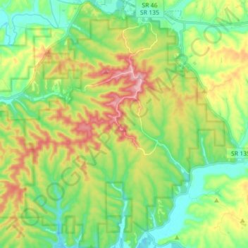
Nom : Carte topographique Brown County State Park, altitude, relief.
Altitude moyenne : 224 m
Altitude minimum : 165 m
Altitude maximum : 324 m
Brown County State Park is sometimes called "the Little Smokies" because of similarities with the Smokey Mountains. Activities available in the park include camping, fishing, biking, hiking, and seasonal horseback riding. Many of these activities are available all year. Overnight visitors may stay in the campgrounds, rental cabins, or the Abe Martin Lodge. The park has a nature center and a nature preserve. Within the park boundaries are two manmade lakes: the 17-acre (6.9 ha) Ogle Lake, and 7-acre (2.8 ha) Strahl Lake. The park contains nine mountain bike trails totaling 25 miles (40 km). Four of the trails are rated as beginner trails, two are considered intermediate, and two advanced. The last trail is rated for experts and is 4.1 miles (6.6 km) long. A total of slightly over 9 miles (14 km) of hiking trails range from easy to rugged terrain. The park has over 20 miles (32 km) of roads and 70 miles (110 km) of bridle trails. The third highest point in Indiana is located on Trail 10 near a 100 feet (30 m) high fire tower. This point, known as Weed Patch Hill, has an elevation of 1,060 feet (320 m). When settlers first arrived at this hill, they found only a patch of weeds—a tornado had destroyed the trees—leading to the name. Hesitation Point is another vantage point for scenic views.