
Carte topographique The Municipal District of Ratoath
Carte interactive
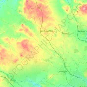
Cliquez sur la carte pour afficher l’altitude.
À propos de cette carte
Nom : Carte topographique The Municipal District of Ratoath, altitude, relief.
Altitude moyenne : 87 m
Altitude minimum : 44 m
Altitude maximum : 162 m
Autres cartes topographiques
Cliquez sur une carte pour visualiser sa topographie, son altitude et son relief.
Moyglare
Moyglare, Rodanstown ED, The Municipal District of Ratoath, County Meath, Leinster, W23 RT91, Ireland
Altitude moyenne : 66 m
Summerhill
Summerhill, Summerhill ED, The Municipal District of Trim, County Meath, Leinster, Ireland
Altitude moyenne : 86 m
Smithstown
Smithstown, Ballinlough ED, The Municipal District of Kells, County Meath, Leinster, Ireland
Altitude moyenne : 121 m
Ballivor
Ballivor, The Municipal District of Trim, County Meath, Leinster, Ireland
Altitude moyenne : 67 m
Clonalvy
Clonalvy, Stamullin ED, The Municipal District of Ashbourne, County Meath, Leinster, Ireland
Altitude moyenne : 102 m
Clonmagaddan
Clonmagaddan, Navan Rural ED, The Municipal District of Navan, County Meath, Leinster, C15 V3K0, Ireland
Altitude moyenne : 52 m
Staleen Lock - Lock 3
Staleen Lock - Lock 3, Duleek ED, The Municipal District of Laytown — Bettystown, County Meath, Leinster, A92 NY2V, Ireland
Altitude moyenne : 50 m
Sarsfieldstown
Sarsfieldstown, Julianstown ED, The Municipal District of Laytown — Bettystown, County Meath, Leinster, Ireland
Altitude moyenne : 25 m
Dunboyne
Dunboyne, Dunboyne ED, The Municipal District of Ratoath, County Meath, Leinster, Ireland
Altitude moyenne : 72 m
Mooretown
Mooretown, Ardcath ED, The Municipal District of Ashbourne, County Meath, Leinster, Ireland
Altitude moyenne : 103 m
Kilwarden
Kilwarden, Ardnamullan ED, The Municipal District of Trim, County Meath, Leinster, Ireland
Altitude moyenne : 72 m
Drumconrath
Drumconrath, Drumcondra ED, The Municipal District of Kells, County Meath, Leinster, Ireland
Altitude moyenne : 47 m
Greenoge
Greenoge, Donaghmore ED, The Municipal District of Ashbourne, County Meath, Leinster, Ireland
Altitude moyenne : 55 m
Donore
Donore, The Municipal District of Laytown — Bettystown, County Meath, Leinster, Ireland
Altitude moyenne : 67 m
Skreen
Skreen, Skreen ED, The Municipal District of Ashbourne, County Meath, Leinster, Ireland
Altitude moyenne : 112 m
Gormanston
Gormanston, Julianstown ED, The Municipal District of Laytown — Bettystown, County Meath, Leinster, K32 H635, Ireland
Altitude moyenne : 18 m
Colp East
Colp East, Saint Mary's ED, The Municipal District of Laytown — Bettystown, County Meath, Leinster, Ireland
Altitude moyenne : 24 m
Ballymaglassan
Ballymaglassan, Culmullin ED, The Municipal District of Ratoath, County Meath, Leinster, Ireland
Altitude moyenne : 99 m
Cruicetown
Cruicetown, Stackallan ED, The Municipal District of Laytown — Bettystown, County Meath, Leinster, Ireland
Altitude moyenne : 60 m
Enfield
Enfield, Innfield ED, The Municipal District of Trim, County Meath, Leinster, Ireland
Altitude moyenne : 77 m
Tara
Tara, The Municipal District of Ashbourne, County Meath, Leinster, Ireland
Altitude moyenne : 91 m
Navan
Navan, The Municipal District of Navan, County Meath, Leinster, Ireland
Altitude moyenne : 52 m
Nobber
Nobber, Nobber ED, The Municipal District of Kells, County Meath, Leinster, Ireland
Altitude moyenne : 61 m
Hurcle
Hurcle, Mellifont ED, The Municipal District of Laytown — Bettystown, County Meath, Leinster, Ireland
Altitude moyenne : 102 m
Castlepole
Castlepole, Castlekeeran ED, The Municipal District of Kells, County Meath, Leinster, Ireland
Altitude moyenne : 85 m
Ballinabrackey
Ballinabrackey, Castlejordan ED, The Municipal District of Trim, County Meath, Leinster, N91 YE0K, Ireland
Altitude moyenne : 82 m
Donaghmore
Donaghmore, Navan Rural ED, The Municipal District of Navan, County Meath, Leinster, Ireland
Altitude moyenne : 63 m
Abbeyland
Abbeyland, Navan Rural ED, The Municipal District of Navan, County Meath, Leinster, Ireland
Altitude moyenne : 48 m
Slane
Slane, The Municipal District of Laytown — Bettystown, County Meath, Leinster, Ireland
Altitude moyenne : 66 m
Trim Castle Keep
Ireland > County Meath > Trim
Trim Castle Keep, Castle Street, Trim, The Municipal District of Trim, County Meath, Leinster, C15 HN90, Ireland
Altitude moyenne : 62 m
The Municipal District of Navan
The Municipal District of Navan, County Meath, Leinster, Ireland
Altitude moyenne : 62 m
Rathkenny
Rathkenny, Rathkenny ED, The Municipal District of Kells, County Meath, Leinster, Ireland
Altitude moyenne : 94 m
Slane
Slane, Slane ED, The Municipal District of Laytown — Bettystown, County Meath, Leinster, Ireland
Altitude moyenne : 69 m
Dunshaughlin
Dunshaughlin, Dunshaughlin Business Park, Dunshaughlin ED, The Municipal District of Ratoath, County Meath, Leinster, Ireland
Altitude moyenne : 100 m
Wilkinstown
Wilkinstown, Donaghpatrick ED, The Municipal District of Kells, County Meath, Leinster, Ireland
Altitude moyenne : 70 m
Cortown
Cortown, Balrathboyne ED, The Municipal District of Kells, County Meath, Leinster, Ireland
Altitude moyenne : 67 m
Ratoath
Ratoath, Ratoath ED, The Municipal District of Ratoath, County Meath, Leinster, Ireland
Altitude moyenne : 85 m
Killeen
Killeen, Killeen ED, The Municipal District of Ratoath, County Meath, Leinster, Ireland
Altitude moyenne : 102 m
Mornington
Mornington, The Municipal District of Laytown — Bettystown, County Meath, Leinster, A92 RK24, Ireland
Altitude moyenne : 11 m
Killallon
Killallon, Killallon ED, The Municipal District of Kells, County Meath, Leinster, Ireland
Altitude moyenne : 108 m
Hill of Down
Hill of Down, Hill of Down ED, The Municipal District of Trim, County Meath, Leinster, Ireland
Altitude moyenne : 73 m
Mullagha
Mullagha, Rathkenny ED, The Municipal District of Kells, County Meath, Leinster, Ireland
Altitude moyenne : 99 m
Proudstown
Proudstown, Navan Rural ED, The Municipal District of Navan, County Meath, Leinster, C15 A623, Ireland
Altitude moyenne : 66 m
Coghalstown
Coghalstown, Rathkenny ED, The Municipal District of Kells, County Meath, Leinster, Ireland
Altitude moyenne : 83 m
Balgeen
Balgeen, Julianstown ED, The Municipal District of Laytown — Bettystown, County Meath, Leinster, Ireland
Altitude moyenne : 41 m
Drumconrath Parish
Drumconrath Parish, County Meath, Leinster, Ireland
Altitude moyenne : 72 m
Knockerk
Knockerk, Slane ED, The Municipal District of Laytown — Bettystown, County Meath, Leinster, Ireland
Altitude moyenne : 110 m
Kilnew
Kilnew, Stamullin ED, The Municipal District of Ashbourne, County Meath, Leinster, Ireland
Altitude moyenne : 95 m
Lisdornan
Lisdornan, Julianstown ED, The Municipal District of Laytown — Bettystown, County Meath, Leinster, Ireland
Altitude moyenne : 59 m