
Carte topographique Arlingham
Carte interactive
Cliquez sur la carte pour afficher l’altitude.
À propos de cette carte
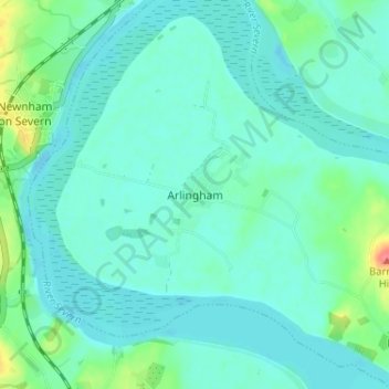
Nom : Carte topographique Arlingham, altitude, relief.
Altitude moyenne : 12 m
Altitude minimum : -1 m
Altitude maximum : 64 m
Autres cartes topographiques
Cliquez sur une carte pour visualiser sa topographie, son altitude et son relief.
Miserden Estate
United Kingdom > England > Gloucestershire > Stroud > Miserden
Altitude moyenne : 218 m
Rodborough Common
United Kingdom > England > Gloucestershire > Stroud > Lightpill
Altitude moyenne : 114 m
River Frome
United Kingdom > England > Gloucestershire > Stroud > Chalford > Chalford Hill
Altitude moyenne : 163 m
Alderley
United Kingdom > England > Gloucestershire > Stroud
In A Topographical Dictionary of England by Samuel Lewis published in 1831, Alderley is described thus.
Altitude moyenne : 95 m
Jubilee Playing Field & Athletics Track
United Kingdom > England > Gloucestershire > Stroud > Cam > Draycott
Altitude moyenne : 45 m
Gloucester and Sharpness Canal
United Kingdom > England > Gloucestershire > Stroud
Altitude moyenne : 34 m