
Carte topographique Upton Country Park
Carte interactive
Cliquez sur la carte pour afficher l’altitude.
À propos de cette carte
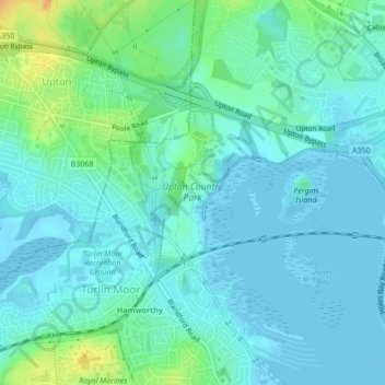
Nom : Carte topographique Upton Country Park, altitude, relief.
Altitude moyenne : 7 m
Altitude minimum : -3 m
Altitude maximum : 32 m
Autres cartes topographiques
Cliquez sur une carte pour visualiser sa topographie, son altitude et son relief.
Poole Harbour
United Kingdom > England > Poole
Poole Harbour, Poole, Bournemouth, Christchurch and Poole, South West England, England, United Kingdom
Altitude moyenne : 11 m