
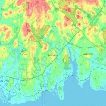
Carte topographique East Lyme
Carte interactive
Cliquez sur la carte pour afficher l’altitude.
À propos de cette carte
Nom : Carte topographique East Lyme, altitude, relief.
Altitude moyenne : 41 m
Altitude minimum : -3 m
Altitude maximum : 152 m
The topography of East Lyme consists of rolling hills and lush valleys rounded by glaciers during the last Ice Age. Hills rise to elevations of 250 to 350 feet (76 to 107 m) above sea level in the eastern and central areas of the town. The highest point in town is an unnamed hill with an elevation of 500 feet (150 m) located in Nehantic State Forest in the northwest corner of the town. East Lyme is especially scenic in the summer when the trees are in bloom. On its east and southern sides, the town abuts tidewater. The tidal Niantic River on the east feeds Niantic Bay, an arm of Long Island Sound, which forms the southern edge of the town.
Autres cartes topographiques
Cliquez sur une carte pour visualiser sa topographie, son altitude et son relief.
New London
United States > Connecticut > Southeastern Connecticut Planning Region
New London, Southeastern Connecticut Planning Region, Connecticut, 06320, United States
Altitude moyenne : 17 m
Groton
United States > Connecticut > Southeastern Connecticut Planning Region
Groton, Southeastern Connecticut Planning Region, Connecticut, United States
Altitude moyenne : 21 m
Graniteville
United States > Connecticut > Southeastern Connecticut Planning Region > Waterford
Graniteville, Waterford, Southeastern Connecticut Planning Region, Connecticut, 06385, United States
Altitude moyenne : 22 m
North Stonington
United States > Connecticut > Southeastern Connecticut Planning Region
North Stonington, Southeastern Connecticut Planning Region, Connecticut, 06338, United States
Altitude moyenne : 73 m
Norwich
United States > Connecticut > Southeastern Connecticut Planning Region
Norwich, Southeastern Connecticut Planning Region, Connecticut, United States
Altitude moyenne : 63 m
Franklin
United States > Connecticut > Southeastern Connecticut Planning Region
Franklin, Southeastern Connecticut Planning Region, Connecticut, 06254, United States
Altitude moyenne : 95 m
Sandy Point
United States > Connecticut > Southeastern Connecticut Planning Region > Waterford
Sandy Point, Waterford, Southeastern Connecticut Planning Region, Connecticut, 06357, United States
Altitude moyenne : 26 m
Avery Pond
United States > Connecticut > Southeastern Connecticut Planning Region > Preston
Avery Pond, Preston, Southeastern Connecticut Planning Region, Connecticut, United States
Altitude moyenne : 51 m
Pawcatuck
United States > Connecticut > Southeastern Connecticut Planning Region > Stonington
Pawcatuck, Stonington, Southeastern Connecticut Planning Region, Connecticut, 06379, United States
Altitude moyenne : 26 m
Waterford
United States > Connecticut > Southeastern Connecticut Planning Region
Waterford, Southeastern Connecticut Planning Region, Connecticut, United States
Altitude moyenne : 30 m
Baltic
United States > Connecticut > Southeastern Connecticut Planning Region > Sprague
Baltic, Sprague, Southeastern Connecticut Planning Region, Connecticut, United States
Altitude moyenne : 81 m
Sprague
United States > Connecticut > Southeastern Connecticut Planning Region
Sprague, Southeastern Connecticut Planning Region, Connecticut, United States
Altitude moyenne : 77 m
Mystic
United States > Connecticut > Southeastern Connecticut Planning Region > Stonington
Mystic, Stonington, Southeastern Connecticut Planning Region, Connecticut, 06388, United States
Altitude moyenne : 17 m
Niantic
United States > Connecticut > Southeastern Connecticut Planning Region > East Lyme
Niantic, East Lyme, Southeastern Connecticut Planning Region, Connecticut, 06357, United States
Altitude moyenne : 12 m
Central Waterford CDP
United States > Connecticut > Southeastern Connecticut Planning Region > Waterford
Central Waterford CDP, Waterford, Southeastern Connecticut Planning Region, Connecticut, 06385, United States
Altitude moyenne : 22 m
Colchester
United States > Connecticut > Southeastern Connecticut Planning Region
Colchester, Southeastern Connecticut Planning Region, Connecticut, 06415, United States
Altitude moyenne : 134 m
Franklin Park
United States > Connecticut > Southeastern Connecticut Planning Region > Norwich
Franklin Park, Little Plain Historic District, Greeneville, Norwich, Southeastern Connecticut Planning Region, Connecticut, 06360, United States
Altitude moyenne : 39 m
Fort Trumbull State Park
United States > Connecticut > Southeastern Connecticut Planning Region > New London
Fort Trumbull State Park, Downtown New London, New London, Southeastern Connecticut Planning Region, Connecticut, 06320, United States
Altitude moyenne : 12 m
Crescent Beach
United States > Connecticut > Southeastern Connecticut Planning Region > East Lyme > Niantic
Crescent Beach, Niantic, East Lyme, Southeastern Connecticut Planning Region, Connecticut, 06357, United States
Altitude moyenne : 9 m
Avon Place/Fieldcrest Play Area
United States > Connecticut > Southeastern Connecticut Planning Region > Groton > Old Mystic
Avon Place/Fieldcrest Play Area, Burnett's Corner Historic District, Old Mystic, Groton, Southeastern Connecticut Planning Region, Connecticut, United States
Altitude moyenne : 36 m
Prospect Hill
United States > Connecticut > Southeastern Connecticut Planning Region > New London
Prospect Hill, New London, Southeastern Connecticut Planning Region, Connecticut, 06385, United States
Altitude moyenne : 38 m
Niantic
United States > Connecticut > Southeastern Connecticut Planning Region > East Lyme > Niantic
Niantic, East Lyme, Southeastern Connecticut Planning Region, Connecticut, United States
Altitude moyenne : 12 m
Montville
United States > Connecticut > Southeastern Connecticut Planning Region
Montville, Southeastern Connecticut Planning Region, Connecticut, United States
Altitude moyenne : 80 m
Uncasville
United States > Connecticut > Southeastern Connecticut Planning Region > Montville
Uncasville, Montville, Southeastern Connecticut Planning Region, Connecticut, 06382, United States
Altitude moyenne : 40 m
Stonington
United States > Connecticut > Southeastern Connecticut Planning Region
Stonington, Southeastern Connecticut Planning Region, Connecticut, United States
Altitude moyenne : 25 m
Salem
United States > Connecticut > Southeastern Connecticut Planning Region
Salem, Southeastern Connecticut Planning Region, Connecticut, 06420, United States
Altitude moyenne : 119 m
Willimantic
United States > Connecticut > Southeastern Connecticut Planning Region
Willimantic, Windham, Southeastern Connecticut Planning Region, Connecticut, 06226, United States
Altitude moyenne : 103 m