
Carte topographique Hickory
Carte interactive
Cliquez sur la carte pour afficher l’altitude.
À propos de cette carte
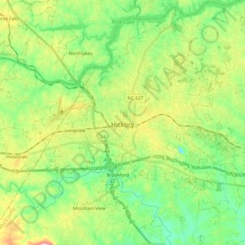
Nom : Carte topographique Hickory, altitude, relief.
Lieu : Hickory, Catawba County, North Carolina, United States (35.66124 -81.40356 35.80737 -81.23537)
Altitude moyenne : 317 m
Altitude minimum : 218 m
Altitude maximum : 512 m
Lake Hickory was named after the City of Hickory and runs along its northern edge. The lake covers almost 4,223 acres (17.09 km2) with 105 miles (169 km) of shoreline. Full pond elevation is 935 feet (285 m). Lake Hickory is a reliable source of water for the Cities of Hickory and Conover and the Town of Long View, while also functioning as a recreation hub for boating, fishing, and other water based activities.
Autres cartes topographiques
Cliquez sur une carte pour visualiser sa topographie, son altitude et son relief.
Long View
United States > North Carolina > Catawba County
Long View, Catawba County, North Carolina, United States
Altitude moyenne : 328 m
Hickory
United States > North Carolina > Catawba County > Hickory
Hickory, Catawba County, North Carolina, 28602, United States
Altitude moyenne : 326 m
Newton
United States > North Carolina > Catawba County
Newton, Catawba County, North Carolina, 28658, United States
Altitude moyenne : 287 m