
Carte topographique Sitka
Carte interactive
Cliquez sur la carte pour afficher l’altitude.
À propos de cette carte
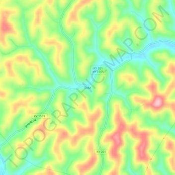
Nom : Carte topographique Sitka, altitude, relief.
Lieu : Sitka, Johnson County, Kentucky, 41255, United States (37.86065 -82.85822 37.90065 -82.81822)
Altitude moyenne : 274 m
Altitude minimum : 193 m
Altitude maximum : 374 m
Autres cartes topographiques
Cliquez sur une carte pour visualiser sa topographie, son altitude et son relief.
Paintsville Lake State Park
United States > Kentucky > Johnson County
Paintsville Lake State Park, Johnson County, Kentucky, United States
Altitude moyenne : 241 m
Paintsville
United States > Kentucky > Johnson County
Paintsville, Johnson County, Kentucky, 41240, United States
Altitude moyenne : 243 m
Paintsville
United States > Kentucky > Johnson County > Paintsville > Paintsville
Paintsville, Johnson County, Kentucky, 41240, United States
Altitude moyenne : 243 m
Volga
United States > Kentucky > Johnson County > Volga
Volga, Johnson County, Kentucky, 41255, United States
Altitude moyenne : 267 m
Staffordsville
United States > Kentucky > Johnson County
Staffordsville, Johnson County, Kentucky, 41256, United States
Altitude moyenne : 238 m
Paintsville Lake
United States > Kentucky > Johnson County
Paintsville Lake, Johnson County, Kentucky, United States
Altitude moyenne : 285 m
Dawkins
United States > Kentucky > Johnson County
Dawkins, Johnson County, Kentucky, 41268, United States
Altitude moyenne : 238 m
West Van Lear
United States > Kentucky > Johnson County
West Van Lear, Johnson County, Kentucky, 41268, United States
Altitude moyenne : 242 m