
Carte topographique Palmerton
Carte interactive
Cliquez sur la carte pour afficher l’altitude.
Palmerton
The borough is located 3 miles (5 km) east of Bowmanstown and 5 miles (8 km) north of the twin towns of Walnutport and Slatington, 7 miles (11 km) southeast of Lehighton, and 58 miles (93 km) south of the city of Scranton. Palmerton's elevation is 407 feet (124 m) above sea level.
À propos de cette carte
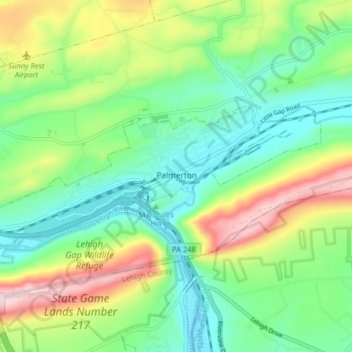
Nom : Carte topographique Palmerton, altitude, relief.
Lieu : Palmerton, Carbon County, Pennsylvania, 18071, United States (40.78919 -75.65770 40.81354 -75.57711)
Altitude moyenne : 230 m
Altitude minimum : 108 m
Altitude maximum : 470 m
Autres cartes topographiques
Cliquez sur une carte pour visualiser sa topographie, son altitude et son relief.
Hickory Run State Park
United States > Pennsylvania > Carbon County > Kidder Township
Altitude moyenne : 471 m
Beltzville State Park - Parking Lot B
United States > Pennsylvania > Carbon County > Lehighton
Altitude moyenne : 222 m
Albrightsville
United States > Pennsylvania > Carbon County > Kidder Township
Altitude moyenne : 498 m
Albrightsville
United States > Pennsylvania > Carbon County > Kidder Township
Altitude moyenne : 498 m
Lake Harmony
United States > Pennsylvania > Carbon County > Kidder Township > Lake Harmony
Altitude moyenne : 551 m
Holiday Poconos
United States > Pennsylvania > Carbon County > Kidder Township
Altitude moyenne : 519 m
Germans
United States > Pennsylvania > Carbon County > East Penn Township > Germans
Altitude moyenne : 238 m