
Carte topographique Hanbury
Carte interactive
Cliquez sur la carte pour afficher l’altitude.
Hanbury
This locality adjoins the River Dove and includes a steep knoll between much of it and the river, Row Hill; five listed buildings are here all at Grade II. Hanbury's village centre is 0.9 miles (1.4 km) to the south. This hamlet is at an elevation of 61m AOD whereas the village centre of Hanbury is at the start of a steep westward valley at the source of the Salt Brook at 134m AOD.
À propos de cette carte
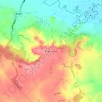
Nom : Carte topographique Hanbury, altitude, relief.
Altitude moyenne : 104 m
Altitude minimum : 56 m
Altitude maximum : 155 m