
Carte topographique Bethlehem
Carte interactive
Cliquez sur la carte pour afficher l’altitude.
À propos de cette carte
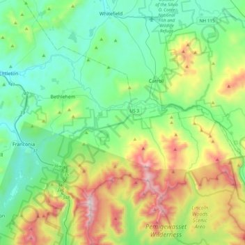
Nom : Carte topographique Bethlehem, altitude, relief.
Altitude moyenne : 528 m
Altitude minimum : 183 m
Altitude maximum : 1’572 m
According to the United States Census Bureau, the town has a total area of 91.0 square miles (235.6 km2), of which 90.6 square miles (234.7 km2) are land and 0.3 square miles (0.9 km2) are water, comprising 0.39% of the town. Bethlehem is drained by the Ammonoosuc, Gale, Zealand and Little rivers, together with Tuttle, Baker and Haystack brooks. Mount Cleveland, elevation 2,397 feet (731 m), and Mount Agassiz, 2,378 ft (725 m), rise to the south of the center of town. Town boundaries contain several of the famous 4,000-footers of New Hampshire: North Twin Mountain (the highest point in Bethlehem at 4,761 ft (1,451 m)), Mount Hale, Mount Tom, Mount Field, and Mount Willey. Bethlehem lies almost fully within the Connecticut River watershed, though a tiny portion of the southeast corner of the town is in the Merrimack River watershed, and an even smaller portion on the east side of the Willey Range is in the Saco River watershed.
Autres cartes topographiques
Cliquez sur une carte pour visualiser sa topographie, son altitude et son relief.
East Hebron
United States > New Hampshire > Grafton County > Hebron
East Hebron, Hebron, Grafton County, New Hampshire, 03241, United States
Altitude moyenne : 268 m
Montcalm
United States > New Hampshire > Grafton County
Montcalm, Grafton County, New Hampshire, 03748, United States
Altitude moyenne : 436 m
Ashland
United States > New Hampshire > Grafton County
Ashland, Grafton County, New Hampshire, 03217, United States
Altitude moyenne : 231 m
Easton
United States > New Hampshire > Grafton County
Easton, Grafton County, New Hampshire, United States
Altitude moyenne : 586 m
Lyme Center
United States > New Hampshire > Grafton County > Lyme
Lyme Center, Lyme, Grafton County, New Hampshire, 03769, United States
Altitude moyenne : 336 m
Pike
United States > New Hampshire > Grafton County > Haverhill
Pike, Haverhill, Grafton County, New Hampshire, 03765, United States
Altitude moyenne : 287 m
Stinson Lake
United States > New Hampshire > Grafton County > Rumney > Stinson Lake
Stinson Lake, Rumney, Grafton County, New Hampshire, United States
Altitude moyenne : 460 m
West Lebanon
United States > New Hampshire > Grafton County > Lebanon
West Lebanon, Lebanon, Grafton County, New Hampshire, 03784, United States
Altitude moyenne : 165 m
Benton
United States > New Hampshire > Grafton County
Benton, Grafton County, New Hampshire, United States
Altitude moyenne : 558 m
Bridgewater
United States > New Hampshire > Grafton County
Bridgewater, Grafton County, New Hampshire, United States
Altitude moyenne : 302 m
Holderness
United States > New Hampshire > Grafton County
Holderness, Grafton County, New Hampshire, 03245, United States
Altitude moyenne : 252 m
Monroe
United States > New Hampshire > Grafton County
Monroe, Grafton County, New Hampshire, 03771, United States
Altitude moyenne : 320 m
North Woodstock
United States > New Hampshire > Grafton County > Woodstock
North Woodstock, Woodstock, Grafton County, New Hampshire, 03262, United States
Altitude moyenne : 306 m
Woodsville
United States > New Hampshire > Grafton County > Haverhill
Woodsville, Haverhill, Grafton County, New Hampshire, 05081, United States
Altitude moyenne : 195 m
Enfield Center
United States > New Hampshire > Grafton County > Enfield
Enfield Center, Enfield, Grafton County, New Hampshire, 03749, United States
Altitude moyenne : 357 m
Glencliff
United States > New Hampshire > Grafton County > Warren
Glencliff, Warren, Grafton County, New Hampshire, 03238, United States
Altitude moyenne : 410 m
Jewell Hill
United States > New Hampshire > Grafton County > Groton
Jewell Hill, Groton, Grafton County, New Hampshire, United States
Altitude moyenne : 466 m
Boutin Corner
United States > New Hampshire > Grafton County > Benton
Boutin Corner, Benton, Grafton County, New Hampshire, United States
Altitude moyenne : 446 m
Russel Pond
United States > New Hampshire > Grafton County > Woodstock
Russel Pond, Woodstock, Grafton County, New Hampshire, United States
Altitude moyenne : 513 m
Bristol
United States > New Hampshire > Grafton County
Bristol, Grafton County, New Hampshire, 03222, United States
Altitude moyenne : 254 m
Pine Knob
United States > New Hampshire > Grafton County > Bethlehem
Pine Knob, Bethlehem, Grafton County, New Hampshire, United States
Altitude moyenne : 413 m
Mount Pemigewasset
United States > New Hampshire > Grafton County > Lincoln
Mount Pemigewasset, Lincoln, Grafton County, New Hampshire, United States
Altitude moyenne : 608 m
Campton Lower Village
United States > New Hampshire > Grafton County > Campton
Campton Lower Village, Campton, Grafton County, New Hampshire, 03223, United States
Altitude moyenne : 260 m
Parker Hill
United States > New Hampshire > Grafton County > Lyman
Parker Hill, Lyman, Grafton County, New Hampshire, United States
Altitude moyenne : 350 m
Cheever
United States > New Hampshire > Grafton County > Dorchester
Cheever, Dorchester, Grafton County, New Hampshire, United States
Altitude moyenne : 330 m
Campton
United States > New Hampshire > Grafton County
Campton, Grafton County, New Hampshire, 03223, United States
Altitude moyenne : 336 m
Sugar Hill
United States > New Hampshire > Grafton County
Sugar Hill, Grafton County, New Hampshire, 03586, United States
Altitude moyenne : 372 m
Ashland Mill Dam
United States > New Hampshire > Grafton County > Ashland
Ashland Mill Dam, Ashland, Grafton County, New Hampshire, 03217, United States
Altitude moyenne : 204 m
Plymouth
United States > New Hampshire > Grafton County
Plymouth, Grafton County, New Hampshire, 03264, United States
Altitude moyenne : 264 m
Ellsworth
United States > New Hampshire > Grafton County
Ellsworth, Grafton County, New Hampshire, United States
Altitude moyenne : 444 m
Waterville Valley
United States > New Hampshire > Grafton County
Waterville Valley, Grafton County, New Hampshire, 03215, United States
Altitude moyenne : 649 m
Goose Pond
United States > New Hampshire > Grafton County > Canaan
Goose Pond, Canaan, Grafton County, New Hampshire, United States
Altitude moyenne : 318 m
Rumney
United States > New Hampshire > Grafton County
Rumney, Grafton County, New Hampshire, 03266, United States
Altitude moyenne : 389 m
Downing Mountain
United States > New Hampshire > Grafton County > Ellsworth
Downing Mountain, Ellsworth, Grafton County, New Hampshire, United States
Altitude moyenne : 445 m
Canaan
United States > New Hampshire > Grafton County
Canaan, Grafton County, New Hampshire, 03741, United States
Altitude moyenne : 404 m
Lyman
United States > New Hampshire > Grafton County
Lyman, Grafton County, New Hampshire, United States
Altitude moyenne : 347 m
Wentworth
United States > New Hampshire > Grafton County
Wentworth, Grafton County, New Hampshire, 03282, United States
Altitude moyenne : 422 m
Hebron
United States > New Hampshire > Grafton County
Hebron, Grafton County, New Hampshire, 03241, United States
Altitude moyenne : 327 m
Fairview
United States > New Hampshire > Grafton County > Woodstock
Fairview, Woodstock, Grafton County, New Hampshire, 03262, United States
Altitude moyenne : 365 m
Bath
United States > New Hampshire > Grafton County
Bath, Grafton County, New Hampshire, 03740, United States
Altitude moyenne : 289 m
Dorchester
United States > New Hampshire > Grafton County
Dorchester, Grafton County, New Hampshire, United States
Altitude moyenne : 439 m
Mountain Lakes
United States > New Hampshire > Grafton County > Haverhill
Mountain Lakes, Haverhill, Grafton County, New Hampshire, 03740, United States
Altitude moyenne : 281 m
Littleton
United States > New Hampshire > Grafton County
Littleton, Grafton County, New Hampshire, 03561, United States
Altitude moyenne : 360 m
Lonesome Lake
United States > New Hampshire > Grafton County > Lincoln
Lonesome Lake, Lincoln, Grafton County, New Hampshire, United States
Altitude moyenne : 810 m
Grafton
United States > New Hampshire > Grafton County
Grafton, Grafton County, New Hampshire, 03240, United States
Altitude moyenne : 409 m
Campton
United States > New Hampshire > Grafton County > Campton > Campton
Campton, Grafton County, New Hampshire, 03223, United States
Altitude moyenne : 255 m
Haverhill
United States > New Hampshire > Grafton County
Haverhill, Grafton County, New Hampshire, United States
Altitude moyenne : 267 m
Woodstock
United States > New Hampshire > Grafton County > Woodstock > Woodstock
Woodstock, Grafton County, New Hampshire, 03262, United States
Altitude moyenne : 333 m
Orange
United States > New Hampshire > Grafton County
Orange, Grafton County, New Hampshire, United States
Altitude moyenne : 457 m
Meadow Brook
United States > New Hampshire > Grafton County
Meadow Brook, Livermore, Grafton County, New Hampshire, United States
Altitude moyenne : 568 m