
Carte topographique Elkins
Carte interactive
Cliquez sur la carte pour afficher l’altitude.
À propos de cette carte
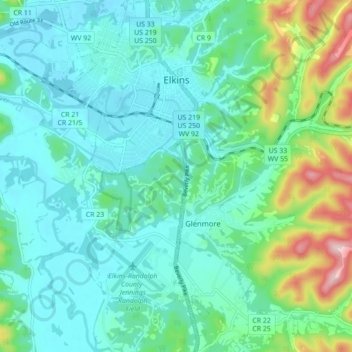
Nom : Carte topographique Elkins, altitude, relief.
Lieu : Elkins, Randolph County, West Virginia, 26241, United States (38.87325 -79.87408 38.94134 -79.83184)
Altitude moyenne : 637 m
Altitude minimum : 576 m
Altitude maximum : 861 m
Elkins is located at the confluence of the Tygart Valley River and Leading Creek. The average elevation is 2,000 feet (610 m) above sea level. According to the United States Census Bureau, the city has a total area of 3.43 square miles (8.88 km2), all land. Elkins is headquarters for the Monongahela National Forest, a 910,155-acre (368,327 ha) federal reserve encompassing the "High Alleghenies" area to the east of the city.
Autres cartes topographiques
Cliquez sur une carte pour visualiser sa topographie, son altitude et son relief.
Bemis
United States > West Virginia > Randolph County
Bemis, Randolph County, West Virginia, 26268, United States
Altitude moyenne : 958 m
Glady
United States > West Virginia > Randolph County
Glady, Randolph County, West Virginia, 26268, United States
Altitude moyenne : 943 m
Montrose
United States > West Virginia > Randolph County
Montrose, Randolph County, West Virginia, United States
Altitude moyenne : 630 m
Whitmer
United States > West Virginia > Randolph County
Whitmer, Randolph County, West Virginia, United States
Altitude moyenne : 972 m
Mill Creek
United States > West Virginia > Randolph County
Mill Creek, Randolph County, West Virginia, United States
Altitude moyenne : 651 m
Adolph
United States > West Virginia > Randolph County
Adolph, Randolph County, West Virginia, 26280, United States
Altitude moyenne : 821 m
Kumbrabow State Forest
United States > West Virginia > Randolph County
Kumbrabow State Forest, Randolph County, West Virginia, United States
Altitude moyenne : 1’013 m
Harman
United States > West Virginia > Randolph County > Harman
Harman, Randolph County, West Virginia, 26760, United States
Altitude moyenne : 814 m
Blue Spring
United States > West Virginia > Randolph County
Blue Spring, Randolph County, West Virginia, 26282, United States
Altitude moyenne : 939 m
White Top
United States > West Virginia > Randolph County
White Top, Randolph County, West Virginia, United States
Altitude moyenne : 1’159 m
Bickle Knob
United States > West Virginia > Randolph County
Bickle Knob, Randolph County, West Virginia, United States
Altitude moyenne : 982 m
Valley Head
United States > West Virginia > Randolph County > Valley Head
Valley Head, Randolph County, West Virginia, 26294, United States
Altitude moyenne : 874 m
Dryfork
United States > West Virginia > Randolph County > Dryfork
Dryfork, Randolph County, West Virginia, 26289, United States
Altitude moyenne : 755 m
Pumpkintown
United States > West Virginia > Randolph County
Pumpkintown, Randolph County, West Virginia, 26278, United States
Altitude moyenne : 743 m