
Carte topographique Spinney Hill Park
Carte interactive
Cliquez sur la carte pour afficher l’altitude.
À propos de cette carte
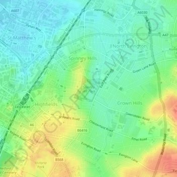
Nom : Carte topographique Spinney Hill Park, altitude, relief.
Altitude moyenne : 73 m
Altitude minimum : 55 m
Altitude maximum : 101 m
Autres cartes topographiques
Cliquez sur une carte pour visualiser sa topographie, son altitude et son relief.
Grand Union Canal
United Kingdom > England > Leicester
Grand Union Canal, Leicester, City of Leicester, East Midlands, England, LE3 5EP, United Kingdom
Altitude moyenne : 65 m
Western Park
United Kingdom > England > Leicester
Western Park, New Parks, Leicester, City of Leicester, East Midlands, England, LE3 6HX, United Kingdom
Altitude moyenne : 88 m
Castle Hill Country Park
United Kingdom > England > Leicester
Castle Hill Country Park, Bradgate Heights, Leicester, City of Leicester, East Midlands, England, United Kingdom
Altitude moyenne : 81 m