
Carte topographique Charleston
Carte interactive
Cliquez sur la carte pour afficher l’altitude.
À propos de cette carte
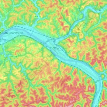
Nom : Carte topographique Charleston, altitude, relief.
Lieu : Charleston, Kanawha County, West Virginia, United States (38.28114 -81.72778 38.40427 -81.55946)
Altitude moyenne : 264 m
Altitude minimum : 172 m
Altitude maximum : 409 m
Charleston has a four-season humid subtropical climate (Köppen Cfa) with continental climate (Dfa) elements. Especially in winter, Charleston's average temperatures are warmer than the rest of the state, due to the city being west of the higher elevations. Spring is the most unpredictable season, and spring-like weather usually arrives in late March or early April. From the beginning of March through early May, temperatures can vary considerably and it is not unusual at this time for day-to-day temperature fluctuations to exceed 20 °F (11 °C). Temperatures warm up considerably in late May, with warm summer-like days. Summer is warm to hot, with 23 days of highs at or above 90 °F (32 °C), sometimes reaching 95 °F (35 °C), often accompanied by high humidity. Autumn features crisp evenings that warm quickly to mild to warm afternoons. Winters are chilly, with a January daily average of 34.4 °F (1.3 °C), and with a mean of 16 days with maxima at or below the freezing mark. Snowfall generally occurs from late November to early April, with the heaviest period being January and February. However, major snowstorms of more than 10 inches (25 cm) are rare. The area averages about 3.5 inches (89 mm) of precipitation each month. Thunderstorms are frequent during the late spring and throughout the summer, and occasionally they can be quite severe, producing the rare tornado.
Autres cartes topographiques
Cliquez sur une carte pour visualiser sa topographie, son altitude et son relief.
Standard
United States > West Virginia > Kanawha County
Standard, Kanawha County, West Virginia, 25083, United States
Altitude moyenne : 397 m
Wilson
United States > West Virginia > Kanawha County
Wilson, Kanawha County, West Virginia, 25302, United States
Altitude moyenne : 246 m
South Charleston
United States > West Virginia > Kanawha County
South Charleston, Kanawha County, West Virginia, United States
Altitude moyenne : 251 m
White Chapel
United States > West Virginia > Kanawha County
White Chapel, Kanawha County, West Virginia, 25320, United States
Altitude moyenne : 238 m
Cabin Creek
United States > West Virginia > Kanawha County
Cabin Creek, Kanawha County, West Virginia, 25035, United States
Altitude moyenne : 296 m
Coal Fork
United States > West Virginia > Kanawha County
Coal Fork, Kanawha County, West Virginia, United States
Altitude moyenne : 295 m
Nitro
United States > West Virginia > Kanawha County
Nitro, Kanawha County, West Virginia, 25143, United States
Altitude moyenne : 220 m
Decota
United States > West Virginia > Kanawha County
Decota, Kanawha County, West Virginia, United States
Altitude moyenne : 547 m
Rand
United States > West Virginia > Kanawha County
Rand, Kanawha County, West Virginia, 25306, United States
Altitude moyenne : 283 m
Cross Lanes
United States > West Virginia > Kanawha County > Cross Lanes
Cross Lanes, Kanawha County, West Virginia, United States
Altitude moyenne : 234 m
St. Albans
United States > West Virginia > Kanawha County
St. Albans, Kanawha County, West Virginia, 25177, United States
Altitude moyenne : 217 m
East Side
United States > West Virginia > Kanawha County > Charleston
East Side, Charleston, Kanawha County, West Virginia, 25389, United States
Altitude moyenne : 222 m
Oakwood
United States > West Virginia > Kanawha County > Charleston
Oakwood, Charleston, Kanawha County, West Virginia, 25314, United States
Altitude moyenne : 257 m
Clendenin
United States > West Virginia > Kanawha County
Clendenin, Kanawha County, West Virginia, United States
Altitude moyenne : 262 m
Elk
United States > West Virginia > Kanawha County > Charleston > Elk
Elk, Charleston, Kanawha County, West Virginia, 25303, United States
Altitude moyenne : 225 m
Sproul
United States > West Virginia > Kanawha County
Sproul, Kanawha County, West Virginia, 25003, United States
Altitude moyenne : 254 m
Loudon Heights
United States > West Virginia > Kanawha County > Charleston > Loudon Heights
Loudon Heights, Charleston, Kanawha County, West Virginia, 25301, United States
Altitude moyenne : 264 m
Tornado
United States > West Virginia > Kanawha County
Tornado, Kanawha County, West Virginia, 25202, United States
Altitude moyenne : 224 m
United
United States > West Virginia > Kanawha County > United
United, Kanawha County, West Virginia, 25060, United States
Altitude moyenne : 607 m
Hernshaw
United States > West Virginia > Kanawha County
Hernshaw, Kanawha County, West Virginia, 25107, United States
Altitude moyenne : 333 m