
Carte topographique Guymon
Carte interactive
Cliquez sur la carte pour afficher l’altitude.
À propos de cette carte
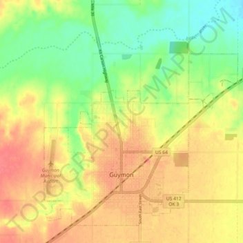
Nom : Carte topographique Guymon, altitude, relief.
Lieu : Guymon, Texas County, Oklahoma, United States (36.66773 -101.51009 36.72926 -101.42046)
Altitude moyenne : 933 m
Altitude minimum : 895 m
Altitude maximum : 969 m
Located on the High Plains of the central Oklahoma Panhandle, Guymon sits 122 miles (196 km) north of Amarillo, Texas, and 120 miles (193 km) west-northwest of Woodward. Optima National Wildlife Refuge, Optima Lake, and the state-run Optima Wildlife Management Area lie roughly 16 miles (26 km) to the east along the North Canadian River. Guymon sits at an elevation of 3,124 feet (952 m). According to the United States Census Bureau, the city has a total area of 7.3 square miles (18.9 km2), of which 7.3 square miles (18.9 km2) are land and 0.04 square miles (0.1 km2) (0.27%) is covered by water.
Autres cartes topographiques
Cliquez sur une carte pour visualiser sa topographie, son altitude et son relief.
Hooker
United States > Oklahoma > Texas County
Hooker, Texas County, Oklahoma, 73945, United States
Altitude moyenne : 911 m
Goodwell
United States > Oklahoma > Texas County
Goodwell, Texas County, Oklahoma, United States
Altitude moyenne : 1’003 m