
Carte topographique Westhill
Carte interactive
Cliquez sur la carte pour afficher l’altitude.
À propos de cette carte
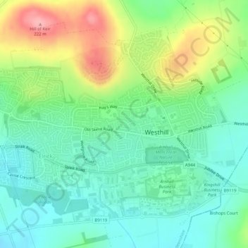
Nom : Carte topographique Westhill, altitude, relief.
Lieu : Westhill, Aberdeenshire, Scotland, United Kingdom (57.14391 -2.31450 57.16520 -2.26555)
Altitude moyenne : 141 m
Altitude minimum : 106 m
Altitude maximum : 221 m
Autres cartes topographiques
Cliquez sur une carte pour visualiser sa topographie, son altitude et son relief.
Nether Cheyne
United Kingdom > Scotland > Aberdeenshire > Kirktown of Fetteresso
Altitude moyenne : 93 m
Braemar
United Kingdom > Scotland > Aberdeenshire
Braemar /breɪˈmɑːr/ (listen) is a village in Aberdeenshire, Scotland, around 58 miles (93 km) west of Aberdeen in the Highlands. It is the closest significantly-sized settlement to the upper course of the River Dee sitting at an elevation of 339 metres (1,112 ft).
Altitude moyenne : 445 m
Ballater
United Kingdom > Scotland > Aberdeenshire
Ballater (/ˈbælətər/, Scottish Gaelic: Bealadair) is a village in Aberdeenshire, Scotland, on the River Dee, immediately east of the Cairngorm Mountains. Situated at an elevation of 213 metres (699 feet), Ballater is a centre for hikers and known for its spring water, once said to cure scrofula. It is home…
Altitude moyenne : 360 m