
Carte topographique Serbie centrale
Carte interactive
Cliquez sur la carte pour afficher l’altitude.
À propos de cette carte
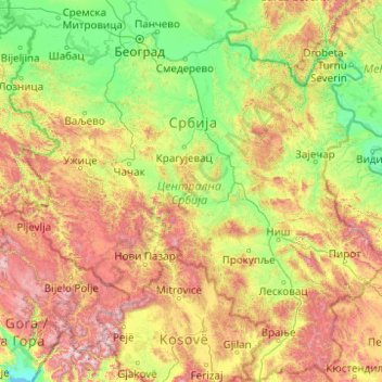
Nom : Carte topographique Serbie centrale, altitude, relief.
Lieu : Serbie centrale, Serbie (42.23145 19.10259 45.09690 23.00631)
Altitude moyenne : 583 m
Altitude minimum : 1 m
Altitude maximum : 2’651 m
Autres cartes topographiques
Cliquez sur une carte pour visualiser sa topographie, son altitude et son relief.
Novi Sad
Serbie > Voïvodine > Јужнобачки управни округ
Novi Sad, Јужнобачки управни округ, Voïvodine, Serbie
Altitude moyenne : 122 m
Градска општина Стари град
Serbie > Serbie centrale > Градска општина Стари град
Градска општина Стари град, Ville de Belgrade, Serbie centrale, Serbie
Altitude moyenne : 90 m
Доњи Таванкут
Доњи Таванкут, Subotica, Град Суботица, Севернобачки управни округ, Voïvodine, 24000, Serbie
Altitude moyenne : 125 m
Копаоник
Serbie > Serbie centrale > Копаоник
Копаоник, Рашки управни округ, Serbie centrale, 36354, Serbie
Altitude moyenne : 1’703 m
Муре
Serbie > Serbie centrale > Општина Рашка
Муре, Општина Рашка, Рашки управни округ, Serbie centrale, Serbie
Altitude moyenne : 553 m