
Carte topographique Tirich Mir
Carte interactive
Cliquez sur la carte pour afficher l’altitude.
À propos de cette carte
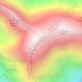
Nom : Carte topographique Tirich Mir, altitude, relief.
Lieu : Tirich Mir, Chitrāl District, Khyber Pakhtunkhwa, Pakistan (36.25404 71.84122 36.25414 71.84132)
Altitude moyenne : 6’886 m
Altitude minimum : 5’538 m
Altitude maximum : 7’666 m
Autres cartes topographiques
Cliquez sur une carte pour visualiser sa topographie, son altitude et son relief.
Mahra
Pakistan > Khyber Pakhtunkhwa > Mahra
Mahra, Khyber Pakhtunkhwa, Pakistan
Altitude moyenne : 166 m
دروش
Pakistan > Khyber Pakhtunkhwa > دروش
دروش, ضلع چترال, Khyber Pakhtunkhwa, Pakistan
Altitude moyenne : 1’851 m
ضلع چترال
ضلع چترال, Upper Dīr District, Khyber Pakhtunkhwa, 17200, Pakistan
Altitude moyenne : 3’685 m
Paney Khwar
Pakistan > Khyber Pakhtunkhwa > سوات
Paney Khwar, سوات, Swāt District, Khyber Pakhtunkhwa, Pakistan
Altitude moyenne : 1’222 m
Abdarra
Pakistan > Khyber Pakhtunkhwa > Abdarra
Abdarra, Peshāwar District, Khyber Pakhtunkhwa, 2500, Pakistan
Altitude moyenne : 377 m
Swabi
Pakistan > Khyber Pakhtunkhwa > Mardan > Swabi
Swabi, Mardan, Mardān District, Khyber Pakhtunkhwa, Pakistan
Altitude moyenne : 358 m
Nowshak
Nowshak, Chitrāl District, Khyber Pakhtunkhwa, Pakistan
Altitude moyenne : 6’863 m
Istor-o-Nal
Istor-o-Nal, Chitrāl District, Khyber Pakhtunkhwa, Pakistan
Altitude moyenne : 6’853 m