
Carte topographique Jaffrey
Carte interactive
Cliquez sur la carte pour afficher l’altitude.
À propos de cette carte
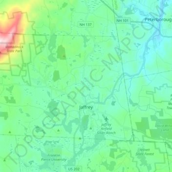
Nom : Carte topographique Jaffrey, altitude, relief.
Altitude moyenne : 351 m
Altitude minimum : 216 m
Altitude maximum : 942 m
Thorndike Pond is in the north, and Contoocook Lake is on the southern boundary. Mount Monadnock, elevation 3,165 feet (965 m) and the highest point in Jaffrey as well as Cheshire County, is in the northwest. Jaffrey lies mostly within the Merrimack River watershed, via the Contoocook River in the eastern part of the town, with the northwest corner of town lying in the Ashuelot River watershed, part of the larger Connecticut River watershed.
Autres cartes topographiques
Cliquez sur une carte pour visualiser sa topographie, son altitude et son relief.
Stoddard
United States > New Hampshire > Cheshire County
Stoddard, Cheshire County, New Hampshire, United States
Altitude moyenne : 451 m
Chesterfield
United States > New Hampshire > Cheshire County
Chesterfield, Cheshire County, New Hampshire, United States
Altitude moyenne : 229 m
Harrisville
United States > New Hampshire > Cheshire County
Harrisville, Cheshire County, New Hampshire, 03450, United States
Altitude moyenne : 422 m
Gilboa Mountain
United States > New Hampshire > Cheshire County > Westmoreland
Gilboa Mountain, Westmoreland, Cheshire County, New Hampshire, 03467, United States
Altitude moyenne : 331 m
Westmoreland
United States > New Hampshire > Cheshire County
Westmoreland, Cheshire County, New Hampshire, 03467, United States
Altitude moyenne : 228 m
Alstead
United States > New Hampshire > Cheshire County
Alstead, Cheshire County, New Hampshire, United States
Altitude moyenne : 289 m
West Chesterfield
United States > New Hampshire > Cheshire County > Chesterfield
West Chesterfield, Chesterfield, Cheshire County, New Hampshire, 03466, United States
Altitude moyenne : 168 m
Rindge
United States > New Hampshire > Cheshire County
Rindge, Cheshire County, New Hampshire, United States
Altitude moyenne : 343 m
Marlborough
United States > New Hampshire > Cheshire County
Marlborough, Cheshire County, New Hampshire, 03455, United States
Altitude moyenne : 299 m
Winchester
United States > New Hampshire > Cheshire County > Winchester
Winchester, Cheshire County, New Hampshire, United States
Altitude moyenne : 167 m
Pisgah State Park
United States > New Hampshire > Cheshire County > Winchester
Pisgah State Park, Winchester, Cheshire County, New Hampshire, United States
Altitude moyenne : 250 m
Keene
United States > New Hampshire > Cheshire County
Keene, Cheshire County, New Hampshire, United States
Altitude moyenne : 263 m
Harper Acres
United States > New Hampshire > Cheshire County > Keene
Harper Acres, Keene, Cheshire County, New Hampshire, 03431, United States
Altitude moyenne : 156 m
Fitzwilliam
United States > New Hampshire > Cheshire County
Fitzwilliam, Cheshire County, New Hampshire, 03447, United States
Altitude moyenne : 345 m
Monte Rosa
United States > New Hampshire > Cheshire County > Jaffrey
Monte Rosa, Jaffrey, Cheshire County, New Hampshire, United States
Altitude moyenne : 634 m