
Carte topographique Nevada
Carte interactive
Cliquez sur la carte pour afficher l’altitude.
À propos de cette carte
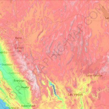
Nom : Carte topographique Nevada, altitude, relief.
Lieu : Nevada, United States (35.00189 -120.00573 42.00038 -114.04030)
Altitude moyenne : 1’475 m
Altitude minimum : -82 m
Altitude maximum : 4’264 m
Much of the northern part of the state is within the Great Basin, a mild desert that experiences hot temperatures in the summer and cold temperatures in the winter. Occasionally, moisture from the Arizona Monsoon will cause summer thunderstorms; Pacific storms may blanket the area with snow. The state's highest recorded temperature was 125 °F (52 °C) in Laughlin (elevation of 605 feet or 184 meters) on June 29, 1994. The coldest recorded temperature was −52 °F (−47 °C) set in San Jacinto in 1972, in the northeastern portion of the state.
Autres cartes topographiques
Cliquez sur une carte pour visualiser sa topographie, son altitude et son relief.
Madison
United States > Wisconsin > Dane County
Madison, Dane County, Wisconsin, United States
Altitude moyenne : 284 m
Jacksonville
United States > Florida > Duval County
Jacksonville, Duval County, Florida, United States
Altitude moyenne : 10 m
Sarasota
United States > Florida > Sarasota County
Sarasota, Sarasota County, Florida, United States
Altitude moyenne : 7 m
Allegheny County
Allegheny County, Pennsylvania, United States
Altitude moyenne : 325 m
Appalachian Mountains
United States > North Carolina > Yancey County
Appalachian Mountains, Yancey County, North Carolina, United States
Altitude moyenne : 1’463 m
Central Park
United States > New York > New York County > New York
Central Park, New York County, New York, United States
Altitude moyenne : 26 m
Brooklyn
United States > New York > New York
Brooklyn, Kings County, New York, United States
Altitude moyenne : 9 m
Taos
United States > New Mexico > Taos County
Taos, Taos County, New Mexico, United States
Altitude moyenne : 2’180 m
Staten Island
United States > New York > New York
Staten Island, Richmond County, New York, United States
Altitude moyenne : 9 m
Lancaster County
Lancaster County, Pennsylvania, United States
Altitude moyenne : 158 m
Sequim
United States > Washington > Clallam County
Sequim, Clallam County, Washington, United States
Altitude moyenne : 88 m
Fairfax County
Fairfax County, Virginia, United States
Altitude moyenne : 75 m
Santa Fe
United States > New Mexico > Santa Fe County
Santa Fe, Santa Fe County, New Mexico, United States
Altitude moyenne : 2’221 m
Boulder
United States > Colorado > Boulder County
Boulder, Boulder County, Colorado, United States
Altitude moyenne : 1’785 m
Seattle
United States > Washington > King County
Seattle, King County, Washington, United States
Altitude moyenne : 40 m
Miami-Dade County
Miami-Dade County, Florida, United States
Altitude moyenne : 3 m