
Carte topographique Gwalior
Carte interactive
Cliquez sur la carte pour afficher l’altitude.
Gwalior
Gwalior is located at 26°13′N 78°11′E / 26.22°N 78.18°E / 26.22; 78.18. in northern Madhya Pradesh 300 km (186 miles) from Delhi. It has an average elevation of 197 metres (646 feet). Most part of it comes under the Bundelkhand area.
À propos de cette carte
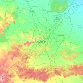
Nom : Carte topographique Gwalior, altitude, relief.
Lieu : Gwalior, Gird Tahsil, Gwalior, Madhya Pradesh, 474001, India (26.04372 77.99736 26.36372 78.31736)
Altitude moyenne : 235 m
Altitude minimum : 165 m
Altitude maximum : 382 m