
Carte topographique Bowling Green
Carte interactive
Cliquez sur la carte pour afficher l’altitude.
À propos de cette carte
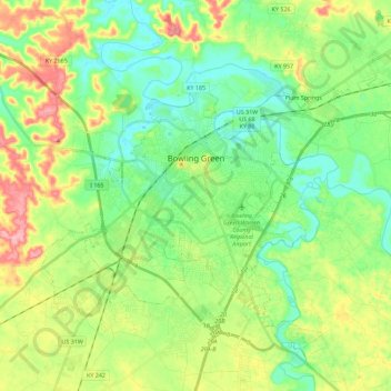
Nom : Carte topographique Bowling Green, altitude, relief.
Lieu : Bowling Green, Warren County, Kentucky, 42101, United States (36.89885 -86.53321 37.04665 -86.30672)
Altitude moyenne : 169 m
Altitude minimum : 127 m
Altitude maximum : 248 m
Autres cartes topographiques
Cliquez sur une carte pour visualiser sa topographie, son altitude et son relief.
Rockfield
United States > Kentucky > Warren County
Rockfield, Warren County, Kentucky, 42274, United States
Altitude moyenne : 179 m
Plano
United States > Kentucky > Warren County
Plano, Warren County, Kentucky, 42102, United States
Altitude moyenne : 182 m
Richardsville
United States > Kentucky > Warren County
Richardsville, Warren County, Kentucky, United States
Altitude moyenne : 182 m
Alvaton
United States > Kentucky > Warren County
Alvaton, Warren County, Kentucky, 42122, United States
Altitude moyenne : 182 m
Smiths Grove
United States > Kentucky > Warren County
Smiths Grove, Warren County, Kentucky, United States
Altitude moyenne : 193 m
Springhill
United States > Kentucky > Warren County > Bowling Green > Springhill
Springhill, Bowling Green, Warren County, Kentucky, 42101-1000, United States
Altitude moyenne : 155 m