
Carte topographique Ketchum
Carte interactive
Cliquez sur la carte pour afficher l’altitude.
À propos de cette carte
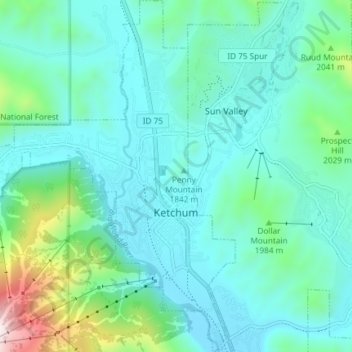
Nom : Carte topographique Ketchum, altitude, relief.
Lieu : Ketchum, Blaine County, Idaho, United States (43.65955 -114.41189 43.71297 -114.35118)
Altitude moyenne : 1’906 m
Altitude minimum : 1’742 m
Altitude maximum : 2’671 m
After the mining boom subsided in the 1890s, sheepmen from the south drove their flocks north through Ketchum in the summer, to graze in the upper elevation areas of the Pioneer, Boulder, and Sawtooth mountains. By 1920, Ketchum had become the largest sheep-shipping center in the West. In the fall, massive flocks of sheep flowed south into the town's livestock corrals at the Union Pacific Railroad's railhead, which connected to the main line at Shoshone.
Autres cartes topographiques
Cliquez sur une carte pour visualiser sa topographie, son altitude et son relief.
Carey
United States > Idaho > Blaine County
Carey, Blaine County, Idaho, 83320, United States
Altitude moyenne : 1’467 m
Sun Valley
United States > Idaho > Blaine County
Sun Valley, Blaine County, Idaho, United States
Altitude moyenne : 1’988 m
Titus Lake
United States > Idaho > Blaine County
Titus Lake, Blaine County, Idaho, United States
Altitude moyenne : 2’736 m
Bellevue
United States > Idaho > Blaine County
Bellevue, Blaine County, Idaho, 83313, United States
Altitude moyenne : 1’667 m
Hailey
United States > Idaho > Blaine County
Hailey, Blaine County, Idaho, 83333, United States
Altitude moyenne : 1’729 m