
Carte topographique Baltimore
Carte interactive
Cliquez sur la carte pour afficher l’altitude.
À propos de cette carte
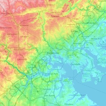
Nom : Carte topographique Baltimore, altitude, relief.
Lieu : Baltimore, Maryland, 21233, United States (39.13088 -76.77076 39.45088 -76.45076)
Altitude moyenne : 65 m
Altitude minimum : -5 m
Altitude maximum : 219 m
Baltimore is in north-central Maryland on the Patapsco River close to where it empties into the Chesapeake Bay. The city is also located on the fall line between the Piedmont Plateau and the Atlantic coastal plain, which divides Baltimore into "lower city" and "upper city". The city's elevation ranges from sea level at the harbor to 480 feet (150 m) in the northwest corner near Pimlico.
Autres cartes topographiques
Cliquez sur une carte pour visualiser sa topographie, son altitude et son relief.
Montgomery County
Montgomery County, Maryland, United States
Altitude moyenne : 120 m
Antietam
United States > Maryland > Washington County
Antietam, Washington County, Maryland, 21782, United States
Altitude moyenne : 123 m
Kent Island
United States > Maryland > Queen Anne's County > Chester
Kent Island, Chester, Queen Anne's County, Maryland, United States
Altitude moyenne : 1 m
College Park
United States > Maryland > Prince George's County
College Park, Prince George's County, Maryland, United States
Altitude moyenne : 38 m
Garrett County
Garrett County, Maryland, United States
Altitude moyenne : 700 m
Harford County
Harford County, Maryland, United States
Altitude moyenne : 70 m
Chesapeake Bay
Chesapeake Bay, Maryland, 23459, United States
Altitude moyenne : 33 m
Anne Arundel County
Anne Arundel County, Maryland, United States
Altitude moyenne : 25 m
Bethesda
United States > Maryland > Bethesda
Bethesda, Montgomery County, Maryland, 22814, United States
Altitude moyenne : 86 m
Carroll County
Carroll County, Maryland, United States
Altitude moyenne : 190 m
Washington County
Washington County, Maryland, United States
Altitude moyenne : 195 m
Annapolis
United States > Maryland > Anne Arundel County
Annapolis, Anne Arundel County, Maryland, United States
Altitude moyenne : 8 m
Flat Run
United States > Maryland > Frederick County > Emmitsburg
Flat Run, Emmitsburg, Frederick County, Maryland, United States
Altitude moyenne : 138 m
Bear Branch
United States > Maryland > Carroll County > Brown Heights
Bear Branch, Brown Heights, Carroll County, Maryland, United States
Altitude moyenne : 145 m
Silver Spring
United States > Maryland > Montgomery County > Silver Spring
Silver Spring, Montgomery County, Maryland, United States
Altitude moyenne : 86 m
Hagerstown
United States > Maryland > Washington County
Hagerstown, Washington County, Maryland, United States
Altitude moyenne : 170 m
Fountain Green
United States > Maryland > Harford County > Bel Air
Fountain Green, Bel Air, Harford County, Maryland, 21015, United States
Altitude moyenne : 106 m
Ocean City
United States > Maryland > Ocean City
Ocean City, Worcester County, Maryland, 21843, United States
Altitude moyenne : 1 m
Gaithersburg
United States > Maryland > Montgomery County
Gaithersburg, Montgomery County, Maryland, United States
Altitude moyenne : 137 m
Mount Airy
United States > Maryland > Carroll County
Mount Airy, Carroll County, Maryland, 21771, United States
Altitude moyenne : 221 m
Hereford
United States > Maryland > Baltimore County
Hereford, Baltimore County, Maryland, United States
Altitude moyenne : 170 m
Keedysville
United States > Maryland > Washington County
Keedysville, Washington County, Maryland, United States
Altitude moyenne : 129 m
Belle Grove Square
United States > Maryland > Carroll County > Westminster
Belle Grove Square, Westminster, Carroll County, Maryland, 21157, United States
Altitude moyenne : 224 m
Owings
United States > Maryland > Calvert County
Owings, Calvert County, Maryland, 20736, United States
Altitude moyenne : 35 m
Laytonsville
United States > Maryland > Montgomery County
Laytonsville, Montgomery County, Maryland, United States
Altitude moyenne : 172 m
Madonna
United States > Maryland > Harford County
Madonna, Harford County, Maryland, 21084, United States
Altitude moyenne : 199 m
Catonsville
United States > Maryland > Baltimore County
Catonsville, Baltimore County, Maryland, 21228, United States
Altitude moyenne : 104 m
Yorktown
United States > Maryland > Anne Arundel County > Glen Burnie
Yorktown, Glen Burnie, Anne Arundel County, Maryland, 21108, United States
Altitude moyenne : 30 m
Auth Village
United States > Maryland > Prince George's County > Camp Springs
Auth Village, Camp Springs, Prince George's County, Maryland, 20746, United States
Altitude moyenne : 77 m
Port Heights
United States > Maryland > Cecil County
Port Heights, Cecil County, Maryland, 21094, United States
Altitude moyenne : 69 m
Frostburg
United States > Maryland > Allegany County
Frostburg, Allegany County, Maryland, 21532, United States
Altitude moyenne : 620 m
Pasadena
United States > Maryland > Anne Arundel County
Pasadena, Anne Arundel County, Maryland, 21122, United States
Altitude moyenne : 16 m
Deer Park
United States > Maryland > Garrett County
Deer Park, Garrett County, Maryland, United States
Altitude moyenne : 774 m
Swanton
United States > Maryland > Garrett County
Swanton, Garrett County, Maryland, 21561, United States
Altitude moyenne : 789 m
Shallmar
United States > Maryland > Garrett County
Shallmar, Garrett County, Maryland, 21538, United States
Altitude moyenne : 653 m
Loch Lynn Heights
United States > Maryland > Garrett County
Loch Lynn Heights, Garrett County, Maryland, United States
Altitude moyenne : 747 m
Saint Inigoes Shores
United States > Maryland > Saint Mary's County
Saint Inigoes Shores, Saint Mary's County, Maryland, 20684, United States
Altitude moyenne : 5 m
Ocean Pines
United States > Maryland > Worcester County
Ocean Pines, Worcester County, Maryland, 21811, United States
Altitude moyenne : 3 m
Damascus
United States > Maryland > Montgomery County
Damascus, Montgomery County, Maryland, 20872, United States
Altitude moyenne : 204 m
Clarksburg
United States > Maryland > Montgomery County
Clarksburg, Montgomery County, Maryland, United States
Altitude moyenne : 166 m
White Oak
United States > Maryland > Montgomery County
White Oak, Montgomery County, Maryland, 20904, United States
Altitude moyenne : 96 m
Perry Hall
United States > Maryland > Baltimore County
Perry Hall, Baltimore County, Maryland, 21236, United States
Altitude moyenne : 72 m
Montgomery Village
United States > Maryland > Montgomery County
Montgomery Village, Montgomery County, Maryland, 20886, United States
Altitude moyenne : 139 m
Glenelg
United States > Maryland > Howard County
Glenelg, Howard County, Maryland, 21737, United States
Altitude moyenne : 171 m
Mount Rainier
United States > Maryland > Prince George's County
Mount Rainier, Prince George's County, Maryland, 20712, United States
Altitude moyenne : 20 m
Dundalk
United States > Maryland > Baltimore County
Dundalk, Baltimore County, Maryland, 21222, United States
Altitude moyenne : 33 m
Catoctin Creek
United States > Maryland > Frederick County > Middletown
Catoctin Creek, Middletown, Frederick County, Maryland, United States
Altitude moyenne : 188 m
Doubs
United States > Maryland > Frederick County > Adamstown
Doubs, Adamstown, Frederick County, Maryland, 21790, United States
Altitude moyenne : 97 m
Weverton
United States > Maryland > Washington County
Weverton, Washington County, Maryland, 21758, United States
Altitude moyenne : 153 m