
Carte topographique Sebring
Carte interactive
Cliquez sur la carte pour afficher l’altitude.
À propos de cette carte
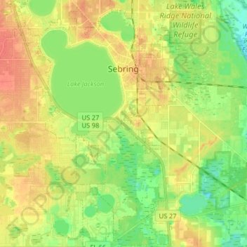
Nom : Carte topographique Sebring, altitude, relief.
Lieu : Sebring, Highlands County, Florida, 33870, United States (27.41266 -81.49922 27.52753 -81.41306)
Altitude moyenne : 34 m
Altitude minimum : 14 m
Altitude maximum : 54 m
Autres cartes topographiques
Cliquez sur une carte pour visualiser sa topographie, son altitude et son relief.
Lake Placid
United States > Florida > Highlands County
Lake Placid, Highlands County, Florida, 33852, United States
Altitude moyenne : 32 m
Lake Huntley
United States > Florida > Highlands County
Lake Huntley, Highlands County, Florida, United States
Altitude moyenne : 30 m
Avon Park
United States > Florida > Highlands County
Avon Park, Highlands County, Florida, 33825, United States
Altitude moyenne : 43 m
Placid Lakes
United States > Florida > Highlands County
Placid Lakes, Highlands County, Florida, United States, Lake August
Altitude moyenne : 34 m
Placid Lakes
United States > Florida > Highlands County
Placid Lakes, Highlands County, Florida, United States
Altitude moyenne : 33 m
Lake Istokpoga
United States > Florida > Highlands County
Lake Istokpoga, Highlands County, Florida, United States
Altitude moyenne : 15 m
Sebring
United States > Florida > Highlands County > Sebring
Sebring, Highlands County, Florida, 33871, United States
Altitude moyenne : 36 m
Venus
United States > Florida > Highlands County
Venus, Highlands County, Florida, 33960, United States
Altitude moyenne : 33 m
Kuhlman
United States > Florida > Highlands County > Kuhlman
Kuhlman, Highlands County, Florida, 33872:33875, United States
Altitude moyenne : 29 m